Sandfloegga
| Sandfloegga | |
|---|---|
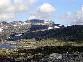 Seen from Holmasjøen (southeast) | |
| Highest point | |
| Elevation | 1,721 m (5,646 ft) |
| Prominence | 540 m (1,770 ft) |
| Isolation | 65.8 kilometres (40.9 mi) |
| Coordinates | 59°56′51″N 07°08′40″E / 59.94750°N 7.14444°ECoordinates: 59°56′51″N 07°08′40″E / 59.94750°N 7.14444°E |
| Geography | |
| Topo map | 1414 IV Haukelisæter |
Sandfloegga or Sandfloeggi is a mountain in Odda municipality in southeastern Hordaland county, Norway. It lies on the southern part of the vast Hardangervidda mountain plateau, and is the highest mountain on Hardangervidda when the bordering summits of Hardangerjøkulen and Folarskardnuten are omitted. The 1,721-metre (5,646 ft) tall mountain lies inside Hardangervidda National Park, about 10 kilometres (6.2 mi) north of the European route E134 highway.[1]
From the summit, the Folgefonna glacier is seen in the northwest, the mountain Hårteigen in the north, the Hallingskarvet mountain ridge in the northeast, and the mountain Gaustatoppen in the east.
References
- ↑ Store norske leksikon. "Sandfloegga" (in Norwegian). Retrieved 2014-06-13.
This article is issued from Wikipedia - version of the 5/30/2015. The text is available under the Creative Commons Attribution/Share Alike but additional terms may apply for the media files.