Santa Ana Department
| Santa Ana | ||
|---|---|---|
| Department | ||
|
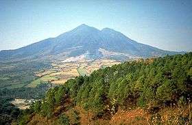
Izalco volcano | ||
| ||
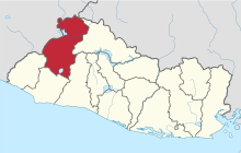 Location within El Salvador | ||
| Coordinates: 14°05′24″N 89°30′40″W / 14.09°N 89.511°WCoordinates: 14°05′24″N 89°30′40″W / 14.09°N 89.511°W | ||
| Country |
| |
| Created (given current status) | 1855 | |
| Seat | Santa Ana | |
| Area | ||
| • Total | 2,023.2 km2 (781.2 sq mi) | |
| Area rank | Ranked 4th | |
| Population | ||
| • Total | 572,081 | |
| • Rank | Ranked 3rd | |
| • Density | 280/km2 (730/sq mi) | |
| Time zone | CST (UTC−6) | |
| ISO 3166 code | SV-SA | |
_flag.jpg)
Santa Ana is a department of El Salvador in the northwest of the country. The capital is Santa Ana, one of the largest cities in El Salvador. It has 2,023 km² and a population of over 572,000. The Santa Ana Volcano is in this department.
History
This department was created on February 8, 1855.
During Pre-Columbian times, the area now composing Santa Ana was inhabited by Mayan peoples; among the department's major Mayan archaeological sites are Tazumal and Casa Blanca. Many of the region's inhabitants were members of the Poqomam or Ch'orti' Mayan subgroups.
Between 1200 and 1400 the department of Santa Ana under Lempa River was conquered by the Pipiles. Between 1528 and 1540 the department of Santa Ana was conquered and pacified by the Spaniards. It belonged to the Greater Mayorship of San Salvador and later to the Intendance of San Salvador, being divided in the parties or districts of Santa Ana and Metapán.
From 1824 (year in which the Greater Mayorship of Sonsonate and Intendance of San Salvador unified) it belonged to the department of Sonsonate. The department was created in 1855, along with the present department of Ahuachapán.
The city is home to C.D. FAS of the Primera División. The football club has won 17 national titles, more than any other team, and one CONCACAF Champions' Cup.
Geography
The department of Santa Ana is at an altitude between 500 m and 3000 m. The most important volcanoes are the Ilamatepec or Santa Ana Volcano and the Chingo. Other notable mountains are Green Hill and the Montecristo massif. The main rivers of the department are the Lempa and the Guajoyo rivers.
The most important lakes in the department are Lake Güija on the border with Guatemala near Metapán, and Lake Coatepeque which is in the southern part of the department.
Municipalities
Santa Ana is divided into 13 municipalities:
| Municipality | Territory | Population |
|---|---|---|
| Candelaria de la Frontera | 91.13 km² | 33,550 hab. |
| Chalchuapa | 165.76 km² | 86,200 hab. |
| Coatepeque | 126.85 km² | 48,544 hab. |
| El Congo | 91.43 km² | 22,274 hab. |
| El Porvenir | 52.52 km² | 7,819 hab. |
| Masahuat | 71.23 km² | 5,125 hab. |
| Metapán | 668.36 km² | 59,499 hab. |
| San Antonio Pajonal | 51.92 km² | 4,574 hab. |
| San Sebastián Salitrillo | 42.32 km² | 16,688 hab. |
| Santa Ana | 400.05 km² | 261,568 hab. |
| Santa Rosa Guachipilín | 38.41 km² | 7,909 hab. |
| Santiago de la Frontera | 44.22 km² | 9,150 hab. |
| Texistepeque | 178.97 km² | 20,904 hab. |