Santa Maria della Concezione dei Cappuccini
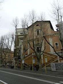

Santa Maria della Concezione dei Cappuccini, or Our Lady of the Conception of the Capuchins, is a church in Rome, Italy, commissioned in 1626 by Pope Urban VIII, whose brother, Antonio Barberini, was a Capuchin friar. It is located at Via Veneto, close to Piazza Barberini.[1]
Interior
The church was designed by Antonio Casoni and built between 1626 and 1631. It comprises a small nave and several side chapels. The chapels are notable as one contains the body of St. Felix of Cantalice and another is the tomb of the Saint Crispin of Viterbo.
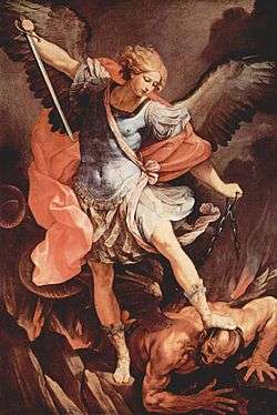
The first chapel has a dramatic altarpiece of St. Michael the Archangel (c.1635) by Guido Reni, and Gherardo delle Notti's Christ Mocked. The second chapel has a Transfiguration by Mario Balassi, and a Nativity (c. 1632) by Lanfranco. The third chapel has a Saint Francis receives stigmata by Domenichino. The fourth chapel houses a Prayer in the Gesthemane (c. 1632) by Baccio Ciarpi. In the fifth chapel is a Saint Anthony by Sacchi, who also painted the Apparition of the Virgin (1645) to Saint Bonaventure in the fifth chapel on the left. The tomb monument for Alexander Sobieski was sculpted by Camillo Rusconi. The third chapel has a Deposition by Andrea Camassei and a Stigmatization of Saint Francis (c. 1570) by Girolamo Muziano. The second chapel has a Santa Felice da Cantalice by Alessandro Turchi, while the first has a painting of Saint Paul restores vision (c. 1631) by Pietro da Cortona.
Crypt
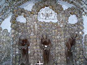
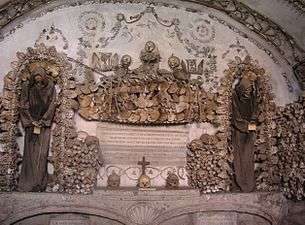
The crypt is located just under the church. Cardinal Antonio Barberini, who was a member of the Capuchin order, in 1631 ordered the remains of thousands of Capuchin friars exhumed and transferred from the friary Via dei Lucchesi to the crypt. The bones were arranged along the walls, and the friars began to bury their own dead here, as well as the bodies of poor Romans, whose tomb was under the floor of the present Mass chapel. Here the Capuchins would come to pray and reflect each evening before retiring for the night.
The crypt, or ossuary, now contains the remains of 4,000 friars buried between 1500 and 1870, during which time the Roman Catholic Church permitted burial in and under churches. The underground crypt is divided into five chapels, lit only by dim natural light seeping in through cracks, and small fluorescent lamps. The crypt walls are decorated with the remains in elaborate fashion, making this crypt a macabre work of art. Some of the skeletons are intact and draped with Franciscan habits, but for the most part, individual bones are used to create elaborate ornamental designs.
The crypt originated at a period of a rich and creative cult for their dead; great spiritual masters meditated and preached with a skull in hand.
A plaque in one of the chapels reads, in three languages, "What you are now, we once were; what we are now, you shall be." This is a memento mori.
The popularity of the crypt as a tourist attraction once rivalled the Catacombs. The Sedlec ossuary (1870) in the Czech Republic and the Skull Chapel in Poland are said to have been inspired by it.

Literary references
Several renowned authors visited the crypt and left descriptions. The Marquis de Sade, who visited the crypt in 1775, wrote, “I have never seen anything more striking” (Voyage d'Italie, p. 106 of the Maurice Lever edition). Mark Twain visited the crypt in the summer of 1867, and begins Chapter XXVIII of The Innocents Abroad with 5 pages of his observations. Nathaniel Hawthorne describes the crypt in his novel The Marble Faun. Additional descriptions were written by authors Tom Weil (1992), Folke Henschen (1965) and Anneli Rufus (1999). See Christine Quigley, Skulls and Skeletons, pp. 175–176.
See also
| Wikimedia Commons has media related to Santa Maria Immacolata a via Veneto (Rome). |
References
- ↑ Rendina, Claudio (1999). Enciclopedia di Roma. Newton Compton.
External links
Coordinates: 41°54′16.7″N 12°29′19.2″E / 41.904639°N 12.488667°E