Sarstoon Island
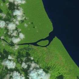 Satellite image of Sarstoon Island taken by Landsat 8 | |
| Geography | |
|---|---|
| Location | Sarstoon River |
| Coordinates | 15°53′28″N 88°55′29″W / 15.8910°N 88.9247°WCoordinates: 15°53′28″N 88°55′29″W / 15.8910°N 88.9247°W |
| Area | 0.65 km2 (0.25 sq mi) |
| Administration | |
|
Belize | |
| District | Toledo |
| Demographics | |
| Population | uninhabited |
Sarstoon Island is an island near the mouth of the Sarstoon River along the Belize–Guatemala border. It is part of the Toledo District of Belize. The island is mostly swampland and is uninhabited.[1] It covers approximately 0.65 square kilometres (0.25 sq mi).
The border between Belize and Guatemala, as demarcated in the Wyke-Aycinena Treaty of 1859, runs along the channel south of the island, making the island part of Belizean territory.[2] However, Guatemala has made claims to the island as part of the Belizean–Guatemalan territorial dispute.[3]
In 2015, the government of Belize announced its intentions to build a forward operating base for the Belize Coast Guard on Sarstoon Island.[3][4] However, due to logistical concerns, the government decided to build the base on the mainland instead.[5]
References
- ↑ "Sarstoon Island Not Suitable for Forward Operating Base". The Guardian. Belize City. August 20, 2015. Retrieved September 13, 2015.
- ↑ Aycinena-Wyke Treaty (PDF), 1859, retrieved March 15, 2016
- 1 2 "PM Barrow confirms Guatemalan Military hostility in Sarstoon Area". The San Pedro Sun. August 26, 2015. Retrieved September 12, 2015.
- ↑ Trujillo, Renee (June 3, 2015). "Government Moves to Install Operating Base at the Sarstoon". LoveFM. Retrieved September 12, 2015.
- ↑ "GOB breaks ground on Sarstoon Base". The Reporter. December 11, 2015. Retrieved March 15, 2016.