Sastavci
| Sastavci Саставци | |
|---|---|
| Village | |
|
| |
| Country |
|
| Entity | Republika Srpska |
| Elevation | −1,200 ft (400-500 m) |
| Population (1999) | |
| • Total | 270 |
| • Density | 180/sq mi (68/km2) |
| Time zone | CET (UTC+1) |
| • Summer (DST) | CEST (UTC+2) |
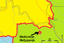
Sastavci is a village in Bosnia and Herzegovina. It is located in Republika Srpska, in Rudo municipality, Foča Region. With an area of 395.84 ha (978.14 acres), it is surrounded by the Serbian municipality of Priboj, in Zlatibor District, making it an exclave of Bosnia and Herzegovina, and an enclave to Serbia.
In 1999, Sastavci had 75 households with a population of 270, of which 25 were Bosniak households comprising 135 people.
Vital infrastructure in the enclave of Sastavci are tied to the Serbian municipality of Priboj. Electrical power is supplied by Serbia and the primary school was built, run and financed by Serbia. A majority of the population is also working in Priboj. However, the land of Sastavci is registered in the registrars' books of municipality of Rudo (Bosnia and Herzegovina), where the population of Sastavci is paying its land tax.
History
The historical origin of the enclave on the territory of Serbia is little known, but is believed to date back the Congress of Berlin 1878 when Austria-Hungary was allowed to annex Bosnia and Herzegovina from the Ottoman Empire, and due to ownership relations from that period, the enclave of Sastavci came to be.
External links
Coordinates: 43°33′30″N 19°25′30″E / 43.5582°N 19.4249°E
| Wikimedia Commons has media related to Sastavci. |