Sawantwadi State
| Savantvadi State सावंतवाडी रियासत | ||||||
| Princely State of British India | ||||||
| ||||||
| ||||||
 | ||||||
| History | ||||||
| • | Established | 1627 | ||||
| • | Independence of India | 1948 | ||||
| Area | ||||||
| • | 1931 | 2,396 km2 (925 sq mi) | ||||
| Population | ||||||
| • | 1931 | 250,589 | ||||
| Density | 104.6 /km2 (270.9 /sq mi) | |||||
| Today part of | Maharashtra, India | |||||
| | ||||||


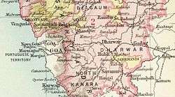
Savantvadi State, also spelt Sawantwadi ruled by the Savant Bhonsale dynasty was one of the non-salute Maratha princely states during the British Raj. It was the only state belonging to the Kolaba Agency under the Bombay Presidency, which became later part of the Deccan States Agency.[1] Its capital was at Sawantwadi, in the present-day Sindhudurg district of Maharashtra.
Sawantvadi State measured 438 square kilometers in area. According to the 1931 census, the population was 250,589. The main language of the inhabitants of the state was Konkani.[2]
History
Savantvadi state was founded in 1627, later becoming a vassal state of the Sultanate of Bijapur. It had some fortified hills, such as Manohar and Mansantosh. On 7 April 1765 Savantvadi State became a British protectorate.
Sawantwadi acceded to the Dominion of India on 15 August 1947, becoming part of Bombay State in 1948.[3]
Rulers
The rulers of Sawantvadi State were Hindu and belonged to the Bhonsale Savant clan. They used the title of Raja Bahadur from 1763 onwards, a hereditary title granted to the head of the family for his services against the Portuguese.[4]
Title Raja Sar Desai
- 1675 – Feb 1709 Khem Savant II Bhonsale (b. 16.. - d. 1709)
- Feb 1709 - 2 Jan 1738 Phond Savant II Bhonsale (b. 1667 - d. 1738)
- 2 Jan 1738 - 1755 Ramachandra Savant I Bhonsale (b. 1712 - d. 1755)
- 2 Jan 1738 - 1753 Jayram Sawant Bhonsale - Regent (d. 1753)
- 1755 – 1763 Khem Savant III Bhonsale (b. 1749 - d. 1803)
- 1755 – 1763 Soubhagyavati Janaki Bai Bhonsale (f) - Regent
Title Raja Bahadur
- 1763 - 6 Oct 1803 Khem Savant III (s.a.)
- 6 Oct 1803 - 1805 Rani Lakshmi Bai (f) - Regent (b. 17.. - d. 1807)
- 1805 - 1807 Ramachandra Savant II "Bhav Sahib" (b. 17.. - d. 1809)
- 1807 – 1808 Phond Savant II (d. 1808)
- 1808 - 3 Oct 1812 Phond Savant III (b. 17.. - d. 1812)
- 1807 – 1808 Rani Durga Bai (f) - Regent (d. 1819) (1st time)
- 3 Oct 1812 - 1867 Khem Savant IV "Bapu Sahib" (b. 1804 - d. 1867)
- 3 Oct 1812 – 28 Dec 1818 Rani Durga Bai (f) - Regent (s.a.) (2nd time)
- 28 Dec 1818 – 11 Feb 1823 Regents
- - Rani Savitri Bai Raje (f)
- - Rani Nurmuda Bai (f) (b. 1783 – d. 1849)
- 1867 - 7 Mar 1869 Phond Savant IV "Bapu Sahib" (b. 1828 - d. 1869)
- 7 Mar 1869 - Dec 1899 Raghunath Savant "Baha Sabib" (b. 1862 - d. 1899)
- 7 Mar 1869 – c.1880 .... -Regent
- Dec 1899 - 23 Apr 1913 Ram Savant "Aba Sahib" (b. 1871 - d. 1913)
- Dec 1899 – 17 Jun 1900 .... -Regent
- 24 Apr 1913 - 4 Jul 1937 Khem Savant V "Bapu Sahib" (b. 1897 - d. 1937) (from 4 Jun 1934, Sir Khem Savant V)
- (Eldest Son of Khem Savant went to England Radhakrishna Samant (Savant)) lost claim to throne
- 24 Apr 1913 - 29 Oct 1924 Rani Gajara Bai Raje (f) – Regent (b. 1887 – d. 19..)
- 4 Jul 1937 - 15 Aug 1947 Shivram Savant (b. 1927 - d. 1995)
- 4 Jul 1937 – 12 May 1947 Rani Parvati Bai Raje (f) - Regent (b. 1907 - d. 1961)
Maratha Generals & Notable Personalities related to Bhonsale Kingdom
- Subhedar of Banda
- Nimbalkar
- Parmaker
See also
- Maratha
- Maratha Empire
- List of Maratha dynasties and states
- Maratha titles
- Political integration of India
References
- ↑ Imperial Gazetteer of India, Oxford: Clarendon Press, 1908
- ↑ Great Britain India Office. The Imperial Gazetteer of India. Oxford: Clarendon Press, 1908.
- ↑ Royal House of Sawantwadi
- ↑ List of rulers of Sawantwadi
Coordinates: 16°00′N 73°45′E / 16.00°N 73.75°E