Schönborn, Brandenburg
Schönborn is a municipality in the Elbe-Elster district, in Brandenburg, Germany.
Demography
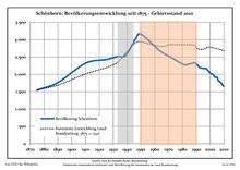
Development of Population since 1875 within the Current Boundaries (Blue Line: Population; Dotted Line: Comparison to Population Development of Brandenburg state; Grey Background: Time of Nazi rule; Red Background: Time of Communist rule)
Schönborn:
Population development within the current boundaries[2]
| Year |
Population |
|---|
| 1875 | 1 547 |
| 1890 | 1 763 |
| 1910 | 2 319 |
| 1925 | 2 426 |
| 1933 | 2 512 |
| 1939 | 2 546 |
| 1946 | 3 011 |
| 1950 | 3 160 |
| 1964 | 2 666 |
| 1971 | 2 507 |
|
|
| Year |
Population |
|---|
| 1981 | 2 280 |
| 1985 | 2 300 |
| 1989 | 2 332 |
| 1990 | 2 290 |
| 1991 | 2 266 |
| 1992 | 2 208 |
| 1993 | 2 188 |
| 1994 | 2 184 |
| 1995 | 2 173 |
| 1996 | 2 167 |
|
|
| Year |
Population |
|---|
| 1997 | 2 173 |
| 1998 | 2 130 |
| 1999 | 2 091 |
| 2000 | 2 041 |
| 2001 | 2 014 |
| 2002 | 1 994 |
| 2003 | 1 937 |
| 2004 | 1 908 |
| 2005 | 1 917 |
| 2006 | 1 820 |
|
|
| Year |
Population |
|---|
| 2007 | 1 791 |
| 2008 | 1 749 |
| 2009 | 1 694 |
| 2010 | 1 647 |
| 2011 | 1 606 |
| 2012 | 1 579 |
| 2013 | 1 593 |
|
|
References


.png)