Schadenbeeksköpfe
| Schadenbeeksköpfe | |
|---|---|
 Schadenbeeksköpfe southeast of Sieber in Osterode am Harz district, Lower Saxony | |
| Highest point | |
| Elevation | 605 m (1,985 ft) |
| Prominence | 10 m |
| Isolation | 0.2 km → Aschentalshalbe |
| Coordinates | 51°40′40″N 10°27′43″E / 51.6777°N 10.462°ECoordinates: 51°40′40″N 10°27′43″E / 51.6777°N 10.462°E |
| Geography | |
| Location | southeast of Sieber in Osterode am Harz district, Lower Saxony |
| Parent range | Harz Mountains |
The Schadenbeeksköpfe are two summits on a southeastern outlier of the Aschentalshalbe in the Harz Mountains of Germany, about 3.6 kilometres southeast of Sieber in the district of Osterode am Harz in Lower Saxony. Their highest peak is 605 metres above sea level. In addition they separate the Schadenbeek stream, after which they were named, from the upper Krumme Lutter. About 1 kilometre east of the Schadenbeeksköpfe lies the Wolkenhügel Pit (Grube Wolkenhügel), in the valley of the Krumme Lutter, which closed in June 2007. A refuge hut not far from the Schadenbeeksköpfe is a checkpoint (no. 153) in the Harzer Wandernadel hiking badge system.
Woods
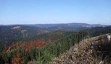
Today the upper slopes of the Schadenbeeksköpfe are mainly covered by spruce whilst, lower down, deciduous woods also occur. In the year 1596 they were still completely covered by beech.[1]
Sources
- Topographische Karte 1:25000, Nr. 4328 Bad Lauterberg im Harz
References
- ↑ Ina Begemann: Palynologische Untersuchungen zur Geschichte von Umwelt und Besiedlung im südwestlichen Harzvorland (unter Einbeziehung geochemischer Befunde), Dissertation zur Erlangung des Doktorgrades der Mathematisch-Naturwissenschaftlichen Fakultäten der Georg-August-Universität zu Göttingen, Göttingen 2003, page 46, Weblink (pdf, 2890kB)