Schoening Peak
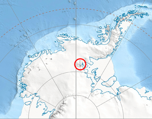
Schoening Peak is a 4,743 metres (15,561 ft) high, steep and rocky peak, at the northeast edge of the ice-covered Vinson Plateau in the Sentinel Range of the Ellsworth Mountains, Antarctica. It surmounts Hinkley Glacier to the north and Dater Glacier to the northeast.
The peak was named by US-ACAN in 2006 after Peter K. Schoening (1927-2004), member of the 1966–67 American Antarctic Mountaineering Expedition that made the first ascent of Mount Vinson, the summit of Antarctica, and other high mountains in the Sentinel Range.[1]
Location
Schoening Peak is located at 78°31′36″S 85°27′57″W / 78.52667°S 85.46583°WCoordinates: 78°31′36″S 85°27′57″W / 78.52667°S 85.46583°W, which is 2.09 miles (3.36 km) east of Mount Vinson, 1.2 miles (1.9 km) northwest of Marts Peak, 3.24 miles (5.21 km) northeast of Opalchenie Peak and 2.91 miles (4.68 km) east-northeast of Silverstein Peak. US mapping in 1961, updated in 1988.
Maps
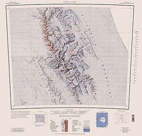
- Vinson Massif. Scale 1:250 000 topographic map. Reston, Virginia: US Geological Survey, 1988.
- Antarctic Digital Database (ADD). Scale 1:250000 topographic map of Antarctica. Scientific Committee on Antarctic Research (SCAR), 1993–2016.
References
- ↑ "Schoening Peak". Geographic Names Information System. United States Geological Survey. Retrieved 2013-11-26.
- Schoening Peak. SCAR Composite Gazetteer of Antarctica.
![]() This article incorporates public domain material from the United States Geological Survey document "Schoening Peak" (content from the Geographic Names Information System).
This article incorporates public domain material from the United States Geological Survey document "Schoening Peak" (content from the Geographic Names Information System).