Schouten Island
|
Map of Schouten Island | |
 Schouten Island Location of Schouten Island in Tasmania | |
| Etymology | In honour of Joost Schouten, a member of the Council of the Dutch East India Company; named in 1642 by Abel Tasman. |
|---|---|
| Geography | |
| Location | East coast of Tasmania |
| Coordinates | 42°18′36″S 148°16′12″E / 42.31000°S 148.27000°E[1]Coordinates: 42°18′36″S 148°16′12″E / 42.31000°S 148.27000°E[2] |
| Archipelago | Schouten Island Group |
| Adjacent bodies of water | Tasman Sea |
| Area | 28 km2 (11 sq mi) |
| Highest elevation | 400 m (1,300 ft) |
| Highest point | Mount Storey |
| Administration | |
|
Australia | |
| State | Tasmania |
| Local government area | Glamorgan Spring Bay Council |
| Additional information | |
| Time zone | |
| • Summer (DST) | |
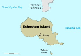
The Schouten Island (formerly Schouten's Isle[3]), part of the Schouten Island Group, is an island with an area of approximately 28 square kilometres (11 sq mi) lying close to the eastern coast of Tasmania, Australia, located 1.6 kilometres (0.99 mi) south of the Freycinet Peninsula[4] and is a part of Freycinet National Park.
History
Schouten Island lies within the territory of the Oyster Bay tribe of Tasmanian Aborigines and kitchen middens indicates Indigenous tribes inhabited the island prior to European settlement.[5][6] In 1642, while surveying the south-west coast of Tasmania, Abel Tasman named the island after Joost Schouten, a member of the Council of the Dutch East India Company.[7]
Members of the Baudin expedition landed on Schouten in 1802. In the early 19th century, sealers were active in the area and are known to have visited the island. The discovery of coal on the island in 1809 by a sealer, John Stacey led to between 1842 and 1925, several phases of coal and tin mining, where in 1880 a small number of Chinese men worked the ground for tin.[5] Stacey found that 200 to 300 hectares (490 to 740 acres) of land could be suitable for cultivation. Plans to use convict labour to mine coal on the island in the 1840s were never realised.[4] From 1850 Schouten was used for grazing sheep, with grazing leases only expiring in 1969.[6][8]
Topography and geology

Schouten is a rugged island with the highest point, Mount Storey, 400 metres (1,300 ft) above sea level. It is surrounded by cliffs, broken by sheltered bays. A north-south fault line exists divides the island where the eastern part of the island is composed of granite while the western part is dolerite overlying sedimentary and supergroup rocks.[8]
Flora and fauna
The natural vegetation of the island is dominated by eucalypt forest on the dolerite soils in the west, and by scrubland, heathland and sedgeland communities on the granitic soils of the east. Areas associated with previous human disturbance, such as clearing, grazing and frequent burning, are dominated by grasses and herbs.[8]
Little penguins and short-tailed shearwaters breed on the island, along with other bird species such as the Tasmanian nativehen. Australian fur seals haul out on the eastern side.[8] Reptiles present include the Tasmanian tree skink, she-oak skink, southern grass skink and three-lined skink.[6]
See also
References
- ↑ "Schouten Island, Tasmania (Islands & Reefs)". Gazetteer of Australia online. Geoscience Australia, Australian Government. Retrieved 29 December 2009.
- ↑ "Schouten Island, Tasmania (Islands & Reefs)". Gazetteer of Australia online. Geoscience Australia, Australian Government. Retrieved 29 December 2009.
- ↑ "Chart of Van Dieman's Land. Map T358" (Map). Digital Maps Collection. National Library of Australia. 1826. Retrieved 12 August 2015.
- 1 2 Bacon, C. A; Corbett, K. D (10 August 1984). "The Schouten Island Coalfield" (PDF). Mineral Resources Tasmania, Department of Infrastructure, Energy and Resources. Tasmanian Government. Retrieved 29 December 2009.
- 1 2 Hughes, T. D (1 January 1959). "Schouten Island" (PDF). Mineral Resources Tasmania, Department of Infrastructure, Energy and Resources. Tasmanian Government. Retrieved 29 December 2009.
- 1 2 3 "Freycinet National Park, Wye River State Reserve, Management Plan" (PDF). Tasmanian Parks & Wildlife Service. Hobart. 2000. ISBN 0-7246-2130-X.
- ↑ "East Coast Islands - Schouten Island Group". Tasmanian Government, Discover Tasmania. Retrieved 15 July 2008.
- 1 2 3 4 Brothers, Nigel; Pemberton, David; Pryor, Helen; Halley, Vanessa (2001). Tasmania’s Offshore Islands: seabirds and other natural features. Hobart: Tasmanian Museum and Art Gallery. pp. 414–6. ISBN 0-7246-4816-X.
Further reading
- "Wineglass Bay, Coles Bay and the Freycinet Peninsular, Tasmania". Freycinet Association Incorporated. Retrieved 15 July 2008.
East Coast region of Tasmania, Australia | |||||||
|---|---|---|---|---|---|---|---|
| Settlements | |||||||
| Governance former | |||||||
| Mountains | |||||||
| Protected areas, parks and reserves |
| ||||||
| Harbours, bays, inlets and estuaries | |||||||
| Landmarks |
| ||||||
| People of note | |||||||
| Islands |
| ||||||
| Books and newspapers | |||||||
| Flora, fauna, and fishlife | |||||||
| Bioregions | |||||||
| |||||||
Australian places named by Dutch explorers in the 17th century1 | ||
|---|---|---|
| Queensland |
|  |
| Northern Territory |
| |
| Western Australia |
| |
| South Australia |
| |
| Tasmania |
| |
| ||