Seddonville
| Seddonville | |
|---|---|
 Seddonville | |
| Coordinates: 41°33′6″S 171°59′24″E / 41.55167°S 171.99000°E | |
| Country | New Zealand |
| Region | West Coast |
| District | Buller District |
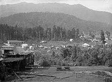
Seddonville is a lightly populated locality[1] on the West Coast of New Zealand's South Island. It is most famous for the historical role it played in New Zealand's coal mining industry.
Geography
Seddonville is in the isolated north of the West Coast in the foothills of the Glasgow Range, on the southern bank of the Mokihinui River. To the west are Summerlea and Mokihinui on the coast of the Tasman Sea, and to the north is Corbyvale on the road to Karamea. State Highway 67 ends just before reaching Seddonville.
A rare mollusc, the Powelliphanta lignaria rotella, is found only in the Seddonville area. It is considered nationally endangered.[2]
History
Seddonville was named after Prime Minister of New Zealand Richard Seddon. It was established in the late 19th century as a mining community after the discovery of significant coal reserves in the area. On 23 February 1895, the last section of the Seddonville Branch railway from Westport was opened from Mokihinui to Seddonville and included an extension to the Mokihinui Coal Company's mine. Passengers were catered for by mixed trains; after 12 June 1933, they ceased to carry passengers past Seddonville, and on 14 October 1946 they were cancelled. Coal was the predominant traffic, especially after the late 1930s when increasingly developed roads allowed most other freight to be carried by road. In 1974, the Mokihinui Coal Company's mine closed, as did the railway beyond Seddonville. Coal from other mines provided some freight for the rest of the decade, but mining production was in decline and demand had dropped, and by 1980 the maintenance cost was well in excess of revenue. The railway closed beyond Ngakawau on 3 May 1981.[3]
Modern age
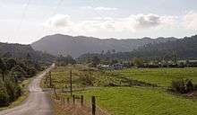
Seddonville is now a small rural village. It provides access to the Mokihinui back country and fishing, tramping, and whitewater rafting attract visitors.[4] The gates to Seddonville Domain form a small war memorial, commemorating 18 men from Seddonville: 13 in World War I and five in World War II.[5] Seddonville houses a library which was named in memory of local MP and first leader of the Labour Party, Harry Holland.[6]
Part of the route of the railway is preserved as the Chasm Creek Walkway. On the approach to Seddonville, it follows the formation of the line, passes through a tunnel and ovedr two railway bridges. The platform of Seddonville railway station is still extant in the village.[7]
References
- ↑ "Place Name Detail: Seddonville". New Zealand Geographic Placenames Database. Land Information New Zealand. Retrieved 23 June 2007.
- ↑ Department of Conservation, New Zealand Threat Classification System lists – 2002 - Terrestrial invertebrate - part one, accessed 23 June 2007.
- ↑ David Leitch and Brian Scott, Exploring New Zealand's Ghost Railways, rev. ed. (Wellington: Grantham House, 1998), 52-3.
- ↑ Tourism West Coast, "Mokihinui / Seddonville", accessed 23 June 2007.
- ↑ Simon Nathan, "Seddonville War Memorial", accessed 23 June 2007.
- ↑ "Harry Holland memorial library". NZHistory.net. Retrieved 2015-07-06.
- ↑ Leitch and Scott, Exploring New Zealand's Ghost Railways, 53-4.
External links
![]() Media related to Seddonville at Wikimedia Commons
Coordinates: 41°33′S 171°59′E / 41.550°S 171.983°E
Media related to Seddonville at Wikimedia Commons
Coordinates: 41°33′S 171°59′E / 41.550°S 171.983°E