Seixal (Porto Moniz)
| Seixal | ||
| Civil Parish | ||
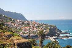 The seaside village of Seixal, along the northern coast of the parish of the same name | ||
|
||
| Official name: Freguesia do Seixal | ||
| Name origin: seixo, Portuguese for pebble | ||
| Country | ||
|---|---|---|
| Autonomous Region | ||
| Island | Madeira | |
| Municipality | Porto Moniz | |
| Localities | Chão da Ribeira, Fanal, Seixal, Feiteiras | |
| Center | Seixal | |
| - elevation | 598 m (1,962 ft) | |
| - coordinates | 32°48′17″N 17°6′37″W / 32.80472°N 17.11028°WCoordinates: 32°48′17″N 17°6′37″W / 32.80472°N 17.11028°W | |
| Lowest point | ||
| - elevation | 0 m (0 ft) | |
| Area | 36.37 km2 (14 sq mi) | |
| Population | 656 (2011) | |
| Density | 18/km2 (47/sq mi) | |
| LAU | Junta Freguesia | |
| - location | Antigo Traçado da ER 101 | |
| Timezone | WET (UTC0) | |
| - summer (DST) | WEST (UTC+1) | |
| Postal Zone | 9270-124 | |
| Area Code & Prefix | (+351) 291 XXX XXX | |
| Demonym | Seixaleiro | |
| Patron Saint | Santo Antão | |
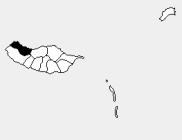 Location of the parish seat of Seixal in the municipality of Porto Moniz, island of Madeira | ||
| Wikimedia Commons: Seixal (Porto Moniz) | ||
| Website: http://www.freguesiaseixal.pt | ||

Seixal is a civil parish in the municipality of Porto Moniz in the Portuguese island of Madeira. The population in 2011 was 656,[1] in an area of 36.37 km².[2]
History
Much like its continental twin, Seixal's name origin came from the abundance of pebbles on the beach.
Geography

Agricultural fields along the slopes of Seixal
It is located on the eastern frontier of Porto Moniz on the border with the municipality of São Vicente. The largest parish in Porto Moniz by area, it extends from the Atlantic Ocean into the interior of Paul de Serra.
References
This article is issued from Wikipedia - version of the 8/26/2014. The text is available under the Creative Commons Attribution/Share Alike but additional terms may apply for the media files.