Serooskerke, Schouwen-Duiveland
| Serooskerke | ||
|---|---|---|
| Village | ||
| ||
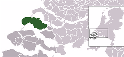 | ||
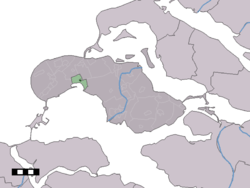 The village centre (dark green) and the statistical district (light green) of Serooskerke in the municipality of Schouwen-Duiveland. | ||
| Coordinates: 51°42′4″N 3°48′53″E / 51.70111°N 3.81472°ECoordinates: 51°42′4″N 3°48′53″E / 51.70111°N 3.81472°E | ||
| Country | Netherlands | |
| Province | Zeeland | |
| Municipality | Schouwen-Duiveland | |
| Population (2-1-2008) | ||
| • Total | 296 | |
| Time zone | CET (UTC+1) | |
| • Summer (DST) | CEST (UTC+2) | |
Serooskerke is a village in the southwest Netherlands. It is located in the municipality of Schouwen-Duiveland, Zeeland about 100 km southwest of Rotterdam.
In 2001, the village of Serooskerke had 225 inhabitants. The built-up area of the village was 0.074 km², and contained 99 residences.[1] The statistical area "Serooskerke", which also can include the surrounding countryside, has a population of around 300.[2]
History
On 1 January 1961, the municipality of Serooskerke merged with the neighboring municipalities of Burgh, Haamstede, Noordwelle, and Renesse to form the municipality of Westenschouwen.[3] On Januari 1997 Westenschouwen merged into the newly formed municipality of Schouwen-Duiveland that is identical in name and area to the island on which Serooskerke is located.
Gallery
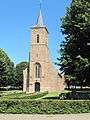 Serooskerke, church
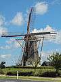 Serooskerke, windmill
People from Serooskerke
- Johannes van de Velde Olivier, printer, publisher and bookseller in Zierikzee
References
- ↑ Statistics Netherlands (CBS), Bevolkingskernen in Nederland 2001 . (Statistics are for the continuous built-up area).
- ↑ Statistics Netherlands (CBS), Statline: Kerncijfers wijken en buurten 2003-2005 . As of 1 January 2005.
- ↑ Ad van der Meer and Onno Boonstra, Repertorium van Nederlandse gemeenten, KNAW, 2006.
External links
| Wikimedia Commons has media related to Serooskerke (Schouwen-Duiveland). |
- J. Kuyper, Gemeente Atlas van Nederland, 1865-1870, "Serooskerke (Schouwen-Duiveland)". Map of the former municipality, around 1868.