Severinghaus Glacier
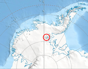
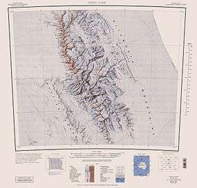
Severinghaus Glacier (78°40′S 85°15′W / 78.667°S 85.250°WCoordinates: 78°40′S 85°15′W / 78.667°S 85.250°W) is a glacier flowing southwestward from Karnare Col along the north side of Mount Strybing and the south side of Mount Craddock into Bender Glacier in southern Sentinel Range, Ellsworth Mountains in Antarctica. Named by the US-ACAN (2006) after Jeffrey P. Severinghaus, University of Rhode Island Graduate School of Oceanography; USAP researcher from 1996 on the history of the atmosphere, including greenhouse gases, and history of climate changes, using the ice core record.
Maps
- Vinson Massif. Scale 1:250 000 topographic map. Reston, Virginia: US Geological Survey, 1988.
References
![]() This article incorporates public domain material from the United States Geological Survey document "Severinghaus Glacier" (content from the Geographic Names Information System).
This article incorporates public domain material from the United States Geological Survey document "Severinghaus Glacier" (content from the Geographic Names Information System).