Shady Hill Historic District
|
Shady Hill Historic District | |
|
Francis Avenue | |
  | |
| Location | Cambridge, Massachusetts |
|---|---|
| Coordinates | 42°22′45″N 71°6′41″W / 42.37917°N 71.11139°WCoordinates: 42°22′45″N 71°6′41″W / 42.37917°N 71.11139°W |
| Area | 26.5 acres (10.7 ha) |
| Architect | Francis, Ebenezer; et al. |
| Architectural style | Mid 19th Century Revival, Late 19th And 20th Century Revivals, Late Victorian |
| MPS | Cambridge MRA |
| NRHP Reference # | [1] |
| Added to NRHP | May 19, 1986 |
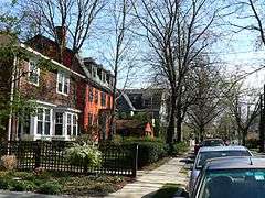
The Shady Hill Historic District is a historic district roughly bounded by Museum, Beacon and Holden, and Kirkland Streets, and Francis Avenue in Cambridge, Massachusetts. The district encompasses a residential area that is one of the city's most homogeneous neighborhoods of the second half of the 19th century. Located just east of the Harvard University campus, the area is characterized by large lot sizes and winding roads, with mature trees providing shade. The houses in the district are predominantly Queen Anne and Colonial Revival in character.[2]
The district was added to the National Register of Historic Places in 1986.[1]
See also
References
- 1 2 National Park Service (2008-04-15). "National Register Information System". National Register of Historic Places. National Park Service.
- ↑ "MACRIS inventory record for Shady Hill Historic District". Commonwealth of Massachusetts. Retrieved 2014-03-23.
| Topics |  | ||||||||||||||||||||||||||||||
|---|---|---|---|---|---|---|---|---|---|---|---|---|---|---|---|---|---|---|---|---|---|---|---|---|---|---|---|---|---|---|---|
| Lists by county | |||||||||||||||||||||||||||||||
| Lists by city |
| ||||||||||||||||||||||||||||||
| Other lists | |||||||||||||||||||||||||||||||
| |||||||||||||||||||||||||||||||
This article is issued from Wikipedia - version of the 11/26/2016. The text is available under the Creative Commons Attribution/Share Alike but additional terms may apply for the media files.