Sherman Historic District (Sherman, Connecticut)
|
Sherman Historic District | |
|
The "Old Store" | |
  | |
| Location | Roughly, jct. of Old Greenswood Rd. and CT 37 Center NE past jct. of CT 37 E and CT 39 N, and Sawmill Rd., Sherman, Connecticut |
|---|---|
| Coordinates | 41°34′44″N 73°29′51″W / 41.57889°N 73.49750°WCoordinates: 41°34′44″N 73°29′51″W / 41.57889°N 73.49750°W |
| Area | 85 acres (34 ha) |
| Architectural style | Greek Revival, Colonial, Federal |
| NRHP Reference # | 91000956[1] |
| Added to NRHP | July 31, 1991 |
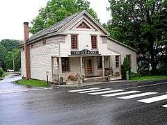
The Sherman Historic District encompasses the historic town center of Sherman, Connecticut. It covers an 85-acre (34 ha) historic district area centered on the junction of Connecticut Routes 37 and 39, and consists mostly of residential structures, some of them dating to not long after the town's incorporation in 1740. Most of the village center was developed in the 19th century. Notable buildings include the 1837 Greek Revival Center Church (now used as a performance space), the 1886 Old Town Hall, and the 1926 Colonial Revival library building.[2]:14
The district was listed on the National Register of Historic Places in 1991.[1]
See also
- Sherman Historic District
- National Register of Historic Places listings in Fairfield County, Connecticut
References
- 1 2 National Park Service (2009-03-13). "National Register Information System". National Register of Historic Places. National Park Service.
- ↑ Jan Cunningham (March 7, 1991). "National Register of Historic Places Registration: Sherman Historic District" (PDF). National Park Service. and Accompanying 18 photos, from 1991 (captions on p. 21 of text document)
| Topics | |
|---|---|
| Lists by states |
|
| Lists by insular areas | |
| Lists by associated states | |
| Other areas | |
| |
This article is issued from Wikipedia - version of the 11/26/2016. The text is available under the Creative Commons Attribution/Share Alike but additional terms may apply for the media files.