Sidi el Barrak Dam
| Sidi el Barrak Dam | |
|---|---|
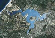 Overhead of dam and reservoir | |
 Location of Sidi el Barrak Dam in Tunisia | |
| Official name | Barrage Sidi el Barrak |
| Country | Tunisia |
| Coordinates | 37°01′29″N 08°56′11″E / 37.02472°N 8.93639°ECoordinates: 37°01′29″N 08°56′11″E / 37.02472°N 8.93639°E |
| Construction began | 1994 |
| Opening date | 2000 |
| Dam and spillways | |
| Type of dam | Embankment |
| Impounds | Oued Zouara River |
| Height | 30 m (98 ft) |
| Length | 500 m (1,640 ft) |
| Dam volume | 2,700,000 m3 (3,531,467 cu yd) |
| Spillway capacity | 517 m3/s (18,258 cu ft/s) |
| Reservoir | |
| Total capacity | 264,000,000 m3 (214,028 acre·ft) |
The Sidi el Barrak Dam is an embankment dam centred 18 km (11 mi) northeast of Tabarak and 2 km (1 mi) from the Mediterranean Sea on the Oued Zouara River in the Beja Governorate, Tunisia. Constructed between 1994 and 2000, the primary purpose of the dam is water supply.[1] As part of the Sidi el Barrak Development Project water stored in the dam is pumped to the Seyjame Dam, at a rate of 265,000,000 m3 (214,839 acre·ft) annually. This water is supplied to Tunis, Cap Bon and the Sahel including Sfax for municipal use along with other agricultural purposes. The entire project was completed in 2002.[2]
References
- ↑ "Sidi el Barrak". Hidrotehnika-Hidroenergetika. Retrieved 22 August 2011.
- ↑ "Sidi el Barrak Dam Completion Report" (PDF). African Development Bank. November 2002. Retrieved 22 August 2011.
This article is issued from Wikipedia - version of the 8/3/2016. The text is available under the Creative Commons Attribution/Share Alike but additional terms may apply for the media files.