Sieversdorf-Hohenofen
Sieversdorf-Hohenofen is a municipality in the Ostprignitz-Ruppin district, in Brandenburg, Germany.
Demography
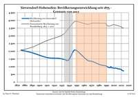
Development of population since 1875 within the current boundaries (Blue line: Population; Dotted line: Comparison to population development of Brandenburg state; Grey background: Time of Nazi rule; Red background: Time of communist rule)
Sieversdorf-Hohenofen:
Population development within the current boundaries (2013)[2]
| Year |
Population |
|---|
| 1875 | 2 070 |
| 1890 | 1 899 |
| 1910 | 1 589 |
| 1925 | 1 542 |
| 1933 | 1 468 |
| 1939 | 1 433 |
| 1946 | 2 043 |
| 1950 | 2 037 |
| 1964 | 1 427 |
| 1971 | 1 335 |
|
|
| Year |
Population |
|---|
| 1981 | 1 129 |
| 1985 | 1 086 |
| 1989 | 1 052 |
| 1990 | 1 030 |
| 1991 | 993 |
| 1992 | 968 |
| 1993 | 947 |
| 1994 | 935 |
| 1995 | 933 |
| 1996 | 1 001 |
|
|
| Year |
Population |
|---|
| 1997 | 928 |
| 1998 | 915 |
| 1999 | 921 |
| 2000 | 903 |
| 2001 | 894 |
| 2002 | 908 |
| 2003 | 896 |
| 2004 | 891 |
| 2005 | 869 |
| 2006 | 843 |
|
|
| Year |
Population |
|---|
| 2007 | 856 |
| 2008 | 846 |
| 2009 | 821 |
| 2010 | 813 |
| 2011 | 756 |
| 2012 | 742 |
| 2013 | 718 |
|
|
References