Sijuwa
| Sijuwa सिजुवा सौठा | |
|---|---|
| Village development committee | |
| Nickname(s): Srijanaga Chowk | |
 Sijuwa Location in Nepal | |
| Coordinates: 26°29′N 87°38′E / 26.48°N 87.63°ECoordinates: 26°29′N 87°38′E / 26.48°N 87.63°E | |
| Country |
|
| Zone | Kosi Zone |
| District | Morang District |
| Time zone | Nepal Time (UTC+5:45) |
| Website | यहा थिच्नुहोस् |
Sijuwa is a village development committee in Morang District in the Kosi Zone of south-eastern Nepal. At the time of the 1991 Nepal census it had a population of 10999 people living in 1971 individual households. Bramhins, Chhetri,Newar,Rai,Satar and Mushar lives here and Rajbanshi and tajpuriya occopies large area for the settlement. The main Occupation of this VDC is the Agriculture. Most of the people earn money by working in the fields . The main Way which originates from Urlabari leads to Biratnagar which is black topped. The High School at Sauntha Bazzar provides the quality education for the children and youths.
The borders are as follows:
North:Itahara
South:Bardanga & Jhurkiya
East:Jhapa
West:Govindapur
[1]
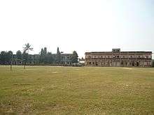
Shree Sauntha higher secondary school
References
- ↑ "Nepal Census 2001". Nepal's Village Development Committees. Digital Himalaya. Retrieved 18 December 2008.

This article is issued from Wikipedia - version of the 12/16/2015. The text is available under the Creative Commons Attribution/Share Alike but additional terms may apply for the media files.