Silberteich
| Silberteich | |
|---|---|
 | |
| Country | Germany |
| Location | Lower Saxony |
| Coordinates | 51°43′27″N 10°34′53″E / 51.72417°N 10.58139°ECoordinates: 51°43′27″N 10°34′53″E / 51.72417°N 10.58139°E |
| Opening date | 1755 |
| Dam and spillways | |
| Height | 8 m |
| Length | 83 m |
The Silberteich is a man-made pond and lies on the upper reaches of the Brunnenbach stream between Braunlage and Sankt Andreasberg in the Harz Mountains of Germany. Originally it was called the Andreasberger Teich or Brunnenbacher Teich, where Teich means 'pond'. Its present name (which means 'Silver Pond') was chosen quite recently to underline its attraction as a tourist destination.
The pond was created in 1755 in order to supply the surrounding ore mines with water power. The Braunlage Blue Glass Factory (Braunlager Blaufarbenwerk), on the site of the present-day Waldmühle, also received its energy from the reservoir.
The pond is about 300 m long with an earth dam about 8 m high. Material for the construction of the dam came from a quarry on the west bank immediately next to the embankment.
The Sankt Andreasberg trail (Sankt Andreasberger Fußstieg), which used to be the shortest route between Braunlage and Sankt Andreasberg, runs along the dam crest. Meanwhile, however, the direct path from the forest pub of Rinderstall on the Oder up to the Silberteich has been largely destroyed by the National Park authorities, so that the journey today requires a detour of more than double the length.
In 1760 after heavy snowfalls in the Harz there was a rapid thaw in February. During the night of 4/5 February the still new dam could no longer hold back the water. It broke and floodwaters poured into the Brunnenbach valley. The waters built up in front of the Brunnenbach Mill, forming a barrier of trees and branches they had brought down with them. The swollen waters looked for a new way out and tore through the mill. Following its rebuilding, the Silberteich was also known until about 1900 as the Neue Teich ('New Pond').
Today the pond is part of a nature reserve. A path runs along the water's edge on the eastern shore. Otherwise paths have been kept some distance away in order to create a quiet zone for flora and fauna.
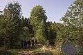 The Andreasberger Stieg trail on the dam crest of the Silberteich dam
 Outflow of the Silberteich into the Brunnenbach from the lake...
 … and the stream side