Silver Moccasin Trail
| Silver Moccasin Trail | |
|---|---|
|
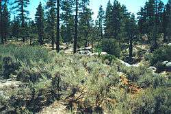
View along the Silver Moccasin Trail | |
| Length | 53 mi (85 km) |
| Location | Los Angeles County, California, USA |
| Trailheads |
Chantry Flat above Arcadia, California Vincent Gap near Wrightwood, California. |
| Use | Hiking, Backpacking |
| Elevation | |
| Highest point | Mount Baden-Powell, 9,407 ft (2,867 m) |
| Hiking details | |
| Trail difficulty | Moderate to strenuous |
The Silver Moccasin Trail is a 53-mile (85 km) trail located in the San Gabriel Mountains, just northeast of Los Angeles. It begins at Chantry Flat Recreation Area above the city of Arcadia, California, traversing upward and down through several canyons and along the high ridges of the Angeles National Forest. This trail connects Mt. Baden-Powell, Mount Burnham, Throop Peak and Mount Hawkins. It comes to its highest point of 9,399 feet (2,865 m) at Mount Baden-Powell after which point it descends to its terminus at Vincent Gap on the Angeles Crest Highway near Wrightwood.
Background
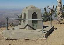
The landscape of the Silver Moccasin Trail varies from lowland chaparral slopes, to oak-lined canyons, to the fir and pine forests of Mt. Baden-Powell, where several Southern California councils of the Boy Scouts of America have placed a monument to their founder, Lord Robert Baden-Powell.[1]
The Silver Moccasin Trail started as a series of Indian trails originally created by the local Native Americans (probably Tongva), but its use was continued by Anglo settlers who either hunted or hiked along its route. In 1942, the Los Angeles Area Council of Boy Scouts established a designated route as the Silver Moccasin Trail, and any Scouts who completed the hike, usually involving several days travel, were qualified to receive the Silver Moccasin Award. Boy Scouts, especially those who are enrolled in “hiking troops,” walk this trail usually as part of a five-day backpack trip.
Alternate starting points, or trailheads, have been established for the SMT more than likely due to overuse or overcrowding at Chantry Flat, which has somewhat reduced the adventuresome attractiveness of the younger, less-traveled version. However, sections of the trail which are only 8 miles (13 km) to 10 miles (16 km) in length while reaching the Baden-Powell summit qualify it as a 20-mile (32 km) (flatland) hike due to gains in elevation which are about 5,000 feet (1,500 m). The Baden-Powell portions of the hike are also beneficial for acclimation to altitudes for beginning hikers who may experience mild altitude sickness between 8,000 feet (2,400 m) and 9,000 feet (2,700 m).
Segments
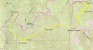
The following segments are listed from the Chantry Flats starting point to the Vincent Gap terminus and show "via routes" and the one-way mileage:
- Chantry Flat to West Fork CG via Gabrielino Trail ... 9 miles (14 km)
- West Fork CG to Angeles Crest Hwy via Shortcut Canyon ... 3 miles (4.8 km)
- Angeles Crest Hwy to Chilao Flat through Charlton Flat ... 7 miles (11 km)
- Chilao Flat to Three Points passes Horse Flats CG ... 5 miles (8.0 km)
- Three Points to Cloudburst Summit via Pacific Crest Trail ... 4 miles (6.4 km)
- Cloudburst Summit to Islip Saddle via Pacific Crest Trail ... 11 miles (18 km)
- Islip Saddle to Mt Baden-Powell via Pacific Crest Trail ... 10 miles (16 km)
- Mt Baden-Powell to Vincent Gap via Pacific Crest Trail ... 4 miles (6.4 km)
Silver Moccasin Award
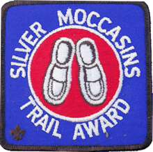
To earn the Silver Moccasin Award patch a youth (at least age 12) or adult must:
- complete one of 3 specified routes: Chantry Flat to Vincent Gap, specific trail near Silliman Crest or Sugarloaf Valley
- earn 2 weekend awards within 90 days of hike start
- make a trip along the Silver Moccasin Trail of at least 5 days
The medal is earned by completing the patch, then completing 12 hours of conservation work.[2]
See also
References
External links
Coordinates: 34°18′23″N 118°00′37″W / 34.30639°N 118.01028°W