Skarfjellet
| Skarfjellet | |
|---|---|
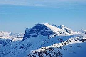 Skarfjellet seen from Vassnebba | |
| Highest point | |
| Elevation | 1,790 m (5,870 ft) |
| Coordinates | 62°42′12″N 08°43′40″E / 62.70333°N 8.72778°ECoordinates: 62°42′12″N 08°43′40″E / 62.70333°N 8.72778°E |
| Geography | |
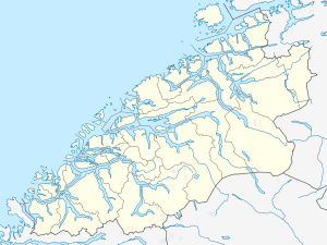 Skarfjellet Location in Møre og Romsdal | |
| Location | Sunndal Municipality, Møre og Romsdal, Norway |
| Parent range | Trollheimen |
| Topo map | 1420 II Romfo |
Skarfjellet is a 1,790-metre (5,870 ft) tall mountain in Sunndal Municipality in Møre og Romsdal county, Norway. It lies along the southern side of the Innerdalen valley, just west of the mountain Innerdalstårnet, and about 9 kilometres (5.6 mi) northeast of the village of Sunndalsøra. It is the northern peak along the Trolla ridge where the highest point is Store Trolla at 1,850 metres (6,070 ft). The mountain is a popular rock climbing destination.[1]
References
- ↑ "Skarfjellet" (in Norwegian). yr.no. Retrieved 2010-12-05.
This article is issued from Wikipedia - version of the 5/29/2015. The text is available under the Creative Commons Attribution/Share Alike but additional terms may apply for the media files.