Skilak Lake
| Skilak Lake | |
|---|---|
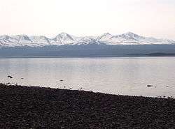 from the beach at lower Skilak campground, Frying Pan Island is visible at lower right | |
| Location | Kenai Peninsula, Alaska |
| Coordinates | 60°24′59″N 150°20′02″W / 60.41639°N 150.33389°WCoordinates: 60°24′59″N 150°20′02″W / 60.41639°N 150.33389°W |
| Primary inflows | Kenai River |
| Primary outflows | Kenai River |
| Basin countries | United States |
| Max. length | 15 mi (24 km) |
| Max. depth | 528 ft (161 m) |
| Frozen | late Nov.- late April |
| Islands | Frying Pan Island, Caribou Island |
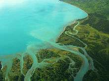
Skilak Lake is a large lake on the Kenai Peninsula, Alaska. The lake is part of the Kenai River system but also contains glacial runoff. The water is exceptionally clear with a mostly rocky bottom, relatively free of aquatic vegetation. It is within the Kenai National Wildlife Refuge, and can be accessed by Skilak Lake Loop Road via the Sterling Highway. Maximum depth is 528 feet (161 m), it is 15 miles (24 km) long and up to 4 miles (6.4 km) wide in places. Early Russian explorers mistakenly believed Skilak and Tustumena Lake to be a single body of water.[1] It is a popular destination for Alaskans due to it being only about a half-hour drive from Soldotna, and about two hours from Anchorage. There are two campgrounds at the lake, one is a developed campground with a host, the other is unhosted and has only basic facilities.[2]
See also
References

- ↑ U.S. Geological Survey Geographic Names Information System: Skilak Lake
- ↑ The Milepost, 59th edition, page 588. ISBN 9781892154217