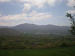
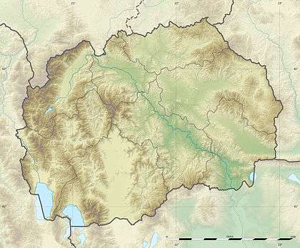
Skopska Crna Gora
Skopska Crna Gora (Macedonian and Serbian Cyrillic: Скопска Црна Гора, pronounced [skôpskaː tsr̩̂ːnaː ɡǒra], meaning "Black Mountain of Skopje", Albanian: Mali i Zi or Malet e Karadakut), also historically known as Karadağ (Turkish for "black mountain"), is a mountain range largely in the Republic of Macedonia, with smaller part in Kosovo[a]. It lies between the cities of Kaçanik (in southern Kosovo) and Skopje (in Macedonia). The highest peak is Ramno (1,651 m (5,417 ft)) in Macedonia.[1] The largest town on the mountain is Kučevište in Macedonia.[1]
Macedonian population of the region speaks the Skopska Crna Gora dialect of the Macedonian language.
Notable people
Culture
- Monastery of St. Nikita, dating to the 14th century, with frescoes by Mihajlo and Eftihie.
References and notes
- Notes
^a Kosovo is the subject of a territorial dispute between the Republic of Kosovo and the Republic of Serbia. The Republic of Kosovo unilaterally declared independence on 17 February 2008, but Serbia continues to claim it as part of its own sovereign territory. The two governments began to normalise relations in 2013, as part of the Brussels Agreement. Kosovo has received recognition as an independent state from 110 out of 193 United Nations member states.
- References
- 1 2 Мала енциклопедија Просвета [Little Encyclopedia of Prosveta] (in Serbo-Croatian). Belgrade: Prosveta. 1969. p. 589.
Sources
- "Skopska Crna Gora", Srpski etnografski zbornik, VI, Belgrade, 1905
|
|---|
|
| Municipalities | | |
|---|
|
| Geography | |
|---|
|
| History | |
|---|
|
| Landmarks | |
|---|
|
| Churches | |
|---|
|
| Museums | |
|---|
|
| Sports venues | |
|---|
|
| Sports clubs | |
|---|
|
| Education | |
|---|
|
| Events | |
|---|
|
| Transportation | |
|---|
|
| People | |
|---|
|
|---|
|
| Geography | | |
|---|
|
| History | |
|---|
|
| Places of interest | Buildings | |
|---|
| Monuments | |
|---|
| Parks | |
|---|
| Squares | |
|---|
| Bridges |
- Iskta bridge
- Mitev bridge
- Sredorek bridge
|
|---|
| Streets |
- Ivo Lola Ribar Nagorichki sokak
- Done Bozinov Proevski sokak
- 11 Oktomvri Ukjumat sokak
- Narodna Revolucija Pchinski pat
- Nikola Tesla Vranjsko dzade
- Ilindenska Romanovski sokak
|
|---|
| Cemetery | |
|---|
|
|---|
|
| Religion |
Orthodox
Churches and
Monasteries | |
|---|
| Sunni Mosques | |
|---|
| Catholic church |
- St. Therese of the Child Jesus
|
|---|
| Protestant church |
- Evangelic church
- Adventist church
- Jehovah's witnesses Church
|
|---|
|
|---|
|
Museums and
Cultural Buildings | |
|---|
|
| Local media | |
|---|
|
| Sport | |
|---|
|
| Education | |
|---|
|
| Events |
- Days of Comedy
- International Art Colony
- Pivtijada
- Summer Jazz Festival (former)
|
|---|
|
Economy and
Transportation | |
|---|
|
| People | |
|---|