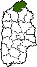
Slavuta Raion
| Slavuta Raion Славутський район | |||
|---|---|---|---|
| Raion | |||
| |||
 | |||
| Country |
| ||
| Region | Khmelnytskyi Oblast | ||
| Established | 1923, 1959 | ||
| Admin. center | Slavuta | ||
| Subdivisions |
List
| ||
| Government | |||
| • Governor | Vasyl V. Kardash | ||
| Area | |||
| • Total | 1,162 km2 (449 sq mi) | ||
| Population | |||
| • Total | 31,301 | ||
| • Density | 27/km2 (70/sq mi) | ||
| Time zone | EET (UTC+2) | ||
| • Summer (DST) | EEST (UTC+3) | ||
| Postal index | 30014—30087 | ||
| Area code | 380-3842 | ||
| Website |
www | ||

Slavuta Raion (Ukrainian: Славутський район) is a raion in Khmelnytskyi Oblast in Ukraine. Its administrative center is Slavuta. Its population is 31 301 inhabitants (01.01.2011).[1] It was established in 1923. 2 cities (Slavuta and Netishyn — cities of regional significance) and 79 villages are located in Slavuta Raion.
Geography
Slavuta Raion is a part of Volhynia. It is one out 20 Raions of Khmelnytskyi Oblast. It is a large raion and ranks as the 7th among the largest with respect to the total area (1 162 km² corresponding to 5.6% of the total area of Khmelnytskyi Oblast).
Slavuta Raion is southeast of Rivne Oblast (Ostroh Raion, Hoshcha Raion and Korets Raion), southwest of Zhytomyr Oblast (Novohrad-Volynskyi Raion and Baranivka Raion), northwest of Shepetivskyi Raion, and northeast of Iziaslavskyi Raion. The Horyn, Korchyk, Tsvitoha and other rivers flow through the district. There is a rail line through the district (Shepetivka—Zdolbuniv).
History
From 1923 to 1932 the district was part of the Shepetivka region, then from 1932 to 1937 it was part of the Vinnytsia region. Following that from 1937 to 1954 it was part of the Kamenets Podolsk region. Since 1954 it has been part of the Khmelnytskyi region. Finally Slavutskyi Raion was formed September 23, 1959.
References
External links
- www.slavuta-rda.com/ (Ukrainian)
-
 Media related to Slavutsky Raion at Wikimedia Commons
 |
Hoscha Raion, Rivne Oblast | Korets Raion, Rivne Oblast | | |
| Ostroh Raion, Rivne Oblast City of Netishyn |
|
Novohrad-Volynskyi Raion, Zhytomyr Oblast | ||
| ||||
| | ||||
| Iziaslav Raion | Shepetivka Raion |
| Raions | |||||||
|---|---|---|---|---|---|---|---|
| Cities |
| ||||||
| |||||||