Smalyavichy Raion
| Smalyavichy Raion Смалявіцкі раён (be) Смолевичский район (ru) | |
|---|---|
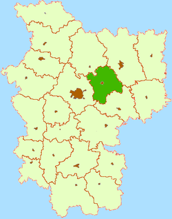 Location of Smalyavichi Raion within Minsk Region | |
| Coordinates: BY 54°01′22″N 28°04′19″E / 54.02278°N 28.07194°ECoordinates: BY 54°01′22″N 28°04′19″E / 54.02278°N 28.07194°E | |
| Country |
|
| Voblast |
|
| Seat | Smalyavichy |
| Government | |
| • Ispolkom | ? |
| Area | |
| • Total | 1,400 km2 (500 sq mi) |
| Population (Not including Zhodzina) | |
| • Total | 46,500 |
| Website | Official website |
Smalyavichy Raion (Belarusian: Смалявіцкі раён; Russian: Смолевичский район, Smolevichi Raion), is a second-level administrative subdivision (raion) of Belarus in Minsk Voblast. Its seat is the town of Smalyavichy[1] but the most populated one is Zhodzina.[2]
History
The district was created on July 17, 1924.
Geography
Overview
Situated in the north-east of its Voblast, Smalyavichy Raion borders with the districts of Minsk, Lahoysk, Barysaw and Chervyen. In its territory is located the International Airport of Minsk. It is crossed by the M1 motorway, part of the European route E30.
Main settlements
- Zhodzina (Belarusian: Жодзiна; Russian: Жодино) - 61,800[3]
- Smalyavichy: (Belarusian: Смалявічы; Russian: Смолевичи) - 14,200
- Zyaleny Bor: (Belarusian: Зялены Бор; Russian: Зеленйы Бор) - around 4,000
Notes and references
- ↑ (Russian) Smalyavichy raion page at Minsk Oblispolkom website
- ↑ Autonomous town
- ↑ (Russian) 2010 Belarus population statistics (RAR file format)
External links
| Wikimedia Commons has media related to Smaliavičy District. |
- (Russian) Smalyavichy Raion official website
- (Russian) District map on emaps-online
| Districts (raiony) |  | |
|---|---|---|
| Cities | ||
1 Seat of the Voblast but administratively separated | ||
This article is issued from Wikipedia - version of the 10/23/2016. The text is available under the Creative Commons Attribution/Share Alike but additional terms may apply for the media files.