Smith River (Umpqua River)
| Smith River | |
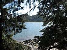
.jpg) Along Lower Smith River Road northeast of Reedsport | |
| Name origin: Jedediah Smith, early 19th century explorer[1] | |
| Country | United States |
|---|---|
| State | Oregon |
| County | Douglas County |
| Source | Central Oregon Coast Range |
| - location | north of Drain, Douglas County, Oregon |
| - elevation | 1,407 ft (429 m) [2] |
| - coordinates | 43°44′25″N 123°20′22″W / 43.74028°N 123.33944°W [3] |
| Mouth | Umpqua River |
| - location | Reedsport, Douglas County, Oregon |
| - elevation | 0 ft (0 m) [3] |
| - coordinates | 43°44′13″N 124°04′43″W / 43.73694°N 124.07861°WCoordinates: 43°44′13″N 124°04′43″W / 43.73694°N 124.07861°W [3] |
| Length | 91 mi (146 km) [4] |
| Basin | 352 sq mi (912 km2) [4] |
| Discharge | |
| - average | 735 cu ft/s (21 m3/s) [4] |
 Location of the mouth of the Smith River in Oregon | |
The Smith River is a 90-mile (140 km) tributary of the Umpqua River in the U.S. state of Oregon.[4] It drains 352 square miles (910 km2) of the Central Oregon Coast Range between the watershed of the Umpqua to the south and the Siuslaw River to the north.[4][5]
Rising in northern Douglas County about 10 miles (16 km) north of Drain, the river flows generally west in a winding course through the mountains, passing through the Siuslaw National Forest for about 10 miles (16 km) in its lower course. It joins the Umpqua from the north across from Reedsport, about 6 miles (10 km) from the mouth of the Umpqua on the Pacific Ocean.[5]
The river is named for Jedediah Smith, who in 1828 led a party of explorers from Utah overland to northern California and southern Oregon. From California, they traveled north to the Umpqua River, camping along its banks near the mouth of the Smith River on July 13. An attack by Native Americans on July 14 killed 15 of Smith's party. One man escaped by heading north to Tillamook and then Fort Vancouver. Smith and two others who were not in camp at the time of the attack fled east toward the Willamette Valley and survived. The Smith River in California is also named for Smith.[1]
Tributaries
Named tributaries of the Smith River from source to mouth are Spring, Whiskey, Alder, Watering Trough, Sleezer, Tip Davis, Peterson, Redford, and Hall creeks. Then Summit, Hefty, Plank, Clevenger, Beaver, Elk, and Arthur Jones creeks. Next is the South Fork Smith River followed by Salmonberry, Amberson, Panther, Haney, Huckleberry, Deer, Yellow, and Hardenbrook creeks.[6]
Next, continuing downstream, are Cleghorn, Johnson, Slideout, Clabber, Halfway, Mosetown, Blind, Rock, Marsh, Devils Club, South Sister and North Sister creeks. Then Beaver, Carpenter, Coldwater, Clearwater, Blackwell, and Scare creeks. Next is the West Fork Smith River followed by Vincent, Rachel, Johnson, Bear, Little Buck, and Buck creeks.[6]
Then come Fawn, Doe, Dailey, Spencer, Taylor, Wasson, and Murphy creeks. Next is the North Fork Smith River followed by Russian John Gulch, then Eslick, Noel, Cassidy, Joyce, Black, and Brainard creeks. Below that are Otter Slough, Camp Seven Gulch, Hudson Slough, Frantz Creek, and Butler Creek.[6]
See also
References
- 1 2 McArthur, pp. 889–90
- ↑ Source elevation derived from Google Earth search using GNIS source coordinates.
- 1 2 3 "Smith River". Geographic Names Information System (GNIS). United States Geological Survey (USGS). November 28, 1980. Retrieved July 23, 2011.
- 1 2 3 4 5 Palmer, Tim (2014). Field Guide to Oregon Rivers. Corvallis: Oregon State University Press. pp. 102–04. ISBN 978-0-87071-627-0.
- 1 2 Oregon Atlas & Gazetteer (7th ed.). Yarmouth, Maine: DeLorme. 2008. pp. 44–46. ISBN 978-0-89933-347-2.
- 1 2 3 "United States Topographic Map". United States Geological Survey. Retrieved December 28, 2015 – via Acme Mapper.
Works cited
- McArthur, Lewis A., and McArthur, Lewis L. (2003) [1928]. Oregon Geographic Names, 7th ed. Portland: Oregon Historical Society Press. ISBN 0-87595-277-1.