Smoking Hills
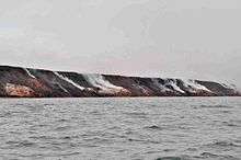
The Smoking Hills are located on the east coast of Cape Bathurst[1] in Canada's Northwest Territories, next to the Arctic Ocean and a small group of lakes. The cliffs were named by explorer John Franklin,[2] who discovered them on his 1826 expeditions. They contain strata of hydrocarbons (oil shales), which have been burning continuously for centuries.
The fires result from autoignition of sulfur-rich lignite deposits. The clouds of smoke have given the region its name. Over time the sulfur dioxide from the smoke has acidified the shallow ponds (< 1 hectare or 2.5 acres area and < 1 metre or 3.3 feet depth) in the tundra dotting the area, down to a pH lower than 2.[3] Elevated concentrations of metals (aluminium, iron, zinc, nickel, manganese and cadmium) occur in these acidic ponds. Soils and sediments have also been chemically altered. The acidic biota in the ponds are characteristic of acidic environments worldwide, in contrast to the typically Arctic biota in adjacent alkaline ponds.[4] Although the soil of the region contains much limestone, the buffer effect has completely disappeared.[5]
The nearest community, Paulatuk, which is about 105 km (65 mi) east, is named in recognition of the coal found in the area, traditionally spelt "Paulatuuq" or "place of coal".[6]
See also
References
- Mathews, WH; Bustin, RM (1984). "Why do the Smoking Hills smoke?". Canadian Journal of Earth Sciences. 21 (7): 737–742. doi:10.1139/e84-080.
- Nakatsu, Cindy; Hutchinson, Thomas C (September 1988). "Extreme Metal and Acid Tolerance of Euglena mutabilis and an Associated Yeast from Smoking Hills, Northwest Territories, and Their Apparent Mutualism". Microbial Ecology. 16 (2): 213–231. doi:10.1007/BF02018915.
- "Smoking Hills". Geographical Names Data Base. Natural Resources Canada. Retrieved 2011-02-04.
- "Topographic Map sheet 97C11". Atlas of Canada. Natural Resources Canada. 2010-02-04. Retrieved 2011-02-04.
- ↑ Freedman, B; Zobens, V; Hutchinson, TC; Gizyn, WI (April 1990). "Intense, Natural Pollution Affects Arctic Tundra Vegetation at the Smoking Hills, Canada". Ecology. 71 (2): 492–503. doi:10.2307/1940303.
- ↑ "The Smoking Hills". Retrieved 2011-02-04.
- ↑ Jernelöv, Arne; Nagell, Björn; Svenson, Anders (April 1981). "Adaptation to an Acid Environment in Chironomus riparius (Diptera, Chironomidae) from Smoking Hills, NWT, Canada". Ecography. 4 (2): 116–119. doi:10.1111/j.1600-0587.1981.tb00987.x.
- ↑ Havas, Magda; Hutchinson, Thomas C (1983-01-06). "The Smoking Hills: natural acidification of an aquatic ecosystem". Nature. 301 (5895): 23–27. doi:10.1038/301023a0.
- ↑ Prof. Hubert van den Bergh: "Atmosphère et climat", Notes de cours, Ecole Poltechnique Fédérale de Lausanne, Switzerland, 2005
- ↑ "Northwest Territories Official Community Names and Pronunciation Guide". Prince of Wales Northern Heritage Centre. Yellowknife: Education, Culture and Employment, Government of the Northwest Territories. Archived from the original on 2016-01-13. Retrieved 2016-01-13.
Coordinates: 69°28′07″N 126°09′02″W / 69.4686°N 126.1505°W