Sokoto
| Sokoto | |
|---|---|
|
Sultan's Palace | |
 Sokoto Location in Nigeria | |
| Coordinates: 13°04′N 5°14′E / 13.067°N 5.233°ECoordinates: 13°04′N 5°14′E / 13.067°N 5.233°E | |
| Country |
|
| State | Sokoto State |
| Government | |
| • Sultan | Sa'adu Abubakar |
| • Governor | Aminu Waziri Tambuwal |
| Population (2006 census)[1] | |
| • Total | 427,760 |
| Climate | BSh |
.JPG)
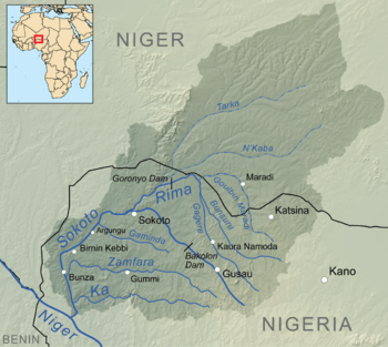
Sokoto is a city located in the extreme northwest of Nigeria, near the confluence of the Sokoto River and the Rima River. As of 2006 it has a population of 427,760. Sokoto is the modern-day capital of Sokoto State (and its predecessor, the north-western State).
The name Sokoto (which is the modern/anglicised version of the local name, Sakkwato) is of Arabic origin, representing suk, 'market'. It is also known as Sakkwato, Birnin Shaihu da Bello or "Sokoto, Capital of Shaihu and Bello".
Being the seat of the Sokoto Caliphate, the city is predominantly Muslim and an important seat of Islamic learning in Nigeria. The Sultan who heads the caliphate is effectively the spiritual leader of Nigerian Muslims.
Climate
Sokoto is in the dry Sahel surrounded by sandy savannah and isolated hills.
With an annual average temperature of 28.3 °C (82.9 °F), Sokoto is one of the hottest cities in the world, however the maximum daytime temperatures are generally under 40 °C (104.0 °F) most of the year, and the dryness makes the heat bearable.[2] The warmest months are February to April, where daytime temperatures can exceed 45 °C (113.0 °F). The highest recorded temperature is 47.2 °C (117.0 °F), which is also the highest recorded temperature in Nigeria. The rainy season is from June to October, during which showers are a daily occurrence. The showers rarely last long and are a far cry from the regular torrential showers known in many tropical regions. From late October to February, during the 'cold season', the climate is dominated by the harmattan wind blowing Sahara dust over the land. The dust dims the sunlight, thereby lowering temperatures significantly and also leading to the inconvenience of dust everywhere in the house.
The region's lifeline for growing crops is the floodplains of the Sokoto-Rima river system, which are covered with rich alluvial soil. For the rest, the general dryness of the region allows for few crops, millet perhaps being the most abundant, complemented by maize, rice, other cereals, and beans.[2][3] Apart from tomatoes, few vegetables grow in the region. The low variety of foodstuffs available has resulted in the relatively dull local cuisine. In terms of vegetation, Sokoto falls within the savannah zone. This is an open tse-tse fly-free grassland suitable for cultivation of grain crops and animal husbandry. Rain starts late and ends early with mean annual rainfall ranging between 500 mm and 1,300 mm. There are two major seasons in Sokoto, namely wet and dry. The dry season starts from October, and lasts up to April in some parts and may extend to May or June in other parts. The wet season on the other hand begins in most parts of the state in May and lasts up to September, or October. The harmattan, a dry, cold and fairly dusty wind is experienced in the state between November and February. Heat is more severe in the state in March and April. But the weather in the state is always cold in the morning and hot in the afternoons, save in peak harmattan period. The topography of the state is dominated by the famous Hausa plain of northern Nigeria. The vast fadama land of the Sokoto-Rima River systems dissects the plain and provides the rich alluvial soil fit for a variety of crop cultivation in the state. There are also isolated hills and mountain ranges scattered all over the state.
| Climate data for Sokoto (1981–2010) | |||||||||||||
|---|---|---|---|---|---|---|---|---|---|---|---|---|---|
| Month | Jan | Feb | Mar | Apr | May | Jun | Jul | Aug | Sep | Oct | Nov | Dec | Year |
| Average high °C (°F) | 32.1 (89.8) |
34.8 (94.6) |
38.6 (101.5) |
40.6 (105.1) |
39.0 (102.2) |
36.2 (97.2) |
32.8 (91) |
31.3 (88.3) |
32.8 (91) |
36.0 (96.8) |
36.1 (97) |
32.9 (91.2) |
35.3 (95.5) |
| Average low °C (°F) | 16.9 (62.4) |
19.4 (66.9) |
23.8 (74.8) |
26.9 (80.4) |
27.3 (81.1) |
25.6 (78.1) |
23.6 (74.5) |
23.1 (73.6) |
23.2 (73.8) |
23.4 (74.1) |
20.5 (68.9) |
17.7 (63.9) |
22.6 (72.7) |
| Average rainfall mm (inches) | 0.0 (0) |
0.1 (0.004) |
1.5 (0.059) |
4.8 (0.189) |
46.5 (1.831) |
80.0 (3.15) |
186.6 (7.346) |
200.5 (7.894) |
109.8 (4.323) |
17.2 (0.677) |
0.0 (0) |
0.0 (0) |
647.0 (25.472) |
| Average rainy days (≥ 0.2 mm) | 0 | 0 | 0 | 1 | 4 | 7 | 11 | 14 | 8 | 2 | 0 | 0 | 47 |
| Average relative humidity (%) | 24 | 19 | 21 | 34 | 50 | 62 | 76 | 83 | 80 | 64 | 36 | 27 | 48 |
| Mean monthly sunshine hours | 288.3 | 268.4 | 275.9 | 255.0 | 272.8 | 279.0 | 229.4 | 186.0 | 237.0 | 303.8 | 300.0 | 300.7 | 3,196.3 |
| Mean daily sunshine hours | 9.3 | 9.5 | 8.9 | 8.5 | 8.8 | 9.3 | 7.4 | 6.0 | 7.9 | 9.8 | 10.0 | 9.7 | 8.4 |
| Source #1: World Meteorological Organization[4] | |||||||||||||
| Source #2: Deutscher Wetterdienst (humidity, 1951–1965 and sun, 1952–1961)[5] | |||||||||||||
Historical development of Sokoto
_(14781116835).jpg)
Sokoto had been used as early as October 1804 by the Shehu Usmanu Dan Fodiyo as the venue for the meeting with Galadima, Yunfa's Vizier. Subsequently, it was used by Muhammad Bello as a staging post for an attack on Dufua in the spring of 1806. Bovil suggested that the area/district may have been known as Sokoto as early as the seventeenth century. In historical perspective, Sokoto was founded as a ribat (military camp or frontier) in 1809, when Shehu Usmanu was at Sifawa. It later became the capital of the caliphate after Shehu's death.
In the 1820s, Sokoto was at its peak of prosperity coinciding with the peak of its `rulers' powers at the center of the caliphate, receiving annual tribute from all the fiefs before a long period of decline. The explorer Hugh Clapperton (1827) was highly impressed by this prosperity and its effects on the city.
Clapperton noted the importance of Sokoto's closely settled surroundings: the rivers, rather than long-distance trade, in the city's economy. But the trade of Sokoto is at present inconsiderable, owing to the disturbed state of the surrounding country.
By the time the explorer Heinrich Barth arrived in 1853 Sokoto was thinly inhabited and greatly dilapidated. Barth in 1857 estimated the population at only 20,000–22,000, but the market was still supplied and attended, and a thriving suburb outside the wall was more animated than Sokoto itself.
Bovil aptly described Sokoto as a strong position, with steep escarpments from the east to the north-west and a small valley on the west and the south west protecting it against surprise cavalry attacks. The town dominates the broad lowland where the two rivers, Rima and Sokoto meet, being the junction of roads from Gobir in the north, Kebbi in the south and Burmi Zamfara in the east.
In the early 19th century, the town (Sokoto) was divided into wards. Such wards include Magajin Gari ward, Waziri ward, Sarkin Musulmi ward, Sarkin Adar ward, Magajin Rafi ward, and Sarkin Zamfara Ward. At this time the wards were small and surrounded with a wall, which included the mosques of Sultan Bello and Shehu, Sultan Palace and other buildings as well as the compound of Shehu.
In 1818, the wall was extended up to the extent that it has gates that come in and out of the Birni wall. Such gates are Kofar-Kade, Kofar-Kware, Kofar-Rini, Kofar-Dundaye, Kofar-Taramniya, Kofar-Aliyu Jedo, and Kofar-Marke.
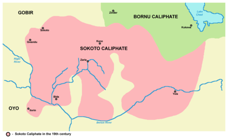
The area of the present Sokoto was the home of many empires and kingdoms of the pre-colonial western Sudan. These include the Gobir and Kebbi kingdoms as well as the world-renowned caliphate whose spiritual and political capital is the headquarters of the state.
Following the conquest of the caliphate by the British in 1903, its various components were made autonomous and joined into the government of Northern Nigeria. The northern region was thus made up of mainly parts of the Sokoto caliphate and Kanem-Bornu Empire. This continued up to January 1967 when states were created to replace regional governments by General Yakubu Gowon. Sokoto became the headquarters of the north-western state created in 1967. In 1976 following the creation of Niger state out of North Western state, Sokoto state emerged with its headquarters. Yet in Sokoto, Kebbi and Zamfara states were carved out of Sokoto, in 1991 and 1996 respectively.
Sokoto metropolis has thus been the capital of various governments since its establishment by Caliph Muhammad Bello in 1809.
People and culture
Sokoto state has a projected population of 3.7 million people based on a 2006 census made up of two ethnic groups namely, Hausa and Fulani. Sokoto town, the capital of Sokoto state, has a population of approximately 2.5 million. Apart from Hausa and Fulani, there are the Zabarmawa and Tuareg minorities in the local government border areas. All these groups speak Hausa as a common language. Fulfulde is spoken by the Fulani.
Hausa people in the state are made up of Gobirawa, Zamfarawa, Kabawa, Adarawa and Arawa. The Fulani on the other hand are of two main groups; the town Fulani (Hausa: Fulanin Gida; Fula: Fulɓe Wuro) and the Nomads. The former includes the Torankawa, the clan of Shehu Usmanu Danfodiyo, Sullubawa and Zoramawa. The Torankawa are the aristocratic class since 1804.
Culturally the state is homogeneous. The people of the state are Muslims and Islamic religion provides them with a code of conduct and behavior. Their mode of dress is also of Islamic origin. Two major festivals namely, Eid-el-Fitri and Eid-el-Kabir are celebrated in the state every year. The former marks the end of the Ramadan fast, while the latter features the slaughtering of rams in commemoration of an act of the Prophet Ibrahim (Abraham).
Traditional wrestling (Kokawa) and boxing (Dambe) are the two sports enjoyed by the Hausa while the Fulani and the Sullubawa entertain themselves with Sharo and Doro respectively. Important visitors to the state are usually treated to the grand or mini durbar, an event involving the parade of heavily decorated horses and camels mounted by men in full traditional military and cultural attire.
Economic activities
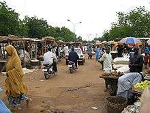
Over eighty percent (80%) of the inhabitants of Sokoto practice one form of agriculture or another. They produce such crops as millet, guinea corn, maize, rice, potatoes, cassava, groundnuts and beans for subsistence and produce wheat, cotton and vegetables for cash. Local crafts such as blacksmithing, weaving, dyeing, carving and leather works also play an important role in the economic life of the people of Sokoto; as a result different areas like Makera, Marina, Takalmawa and Majema became important. Sokoto is also one of the fish producing areas of the country. Thus a large number of people along the river basin engage in fishing as well.
Sokoto is equally endowed with natural and mineral resources. Agro allied industries using cotton, groundnut, sorghum, gum, maize, rice, wheat sugar cane, cassava, gum Arabic and tobacco as raw materials can be established in the area. Large scale farming can also be practiced in the state using irrigation water from Goronyo Dam, Lugu, Kalmalo, Wammakko and Kwakwazo lakes among others.
Minerals such as kaolin, gypsum, limestone, laterite, red mills, phosphate both yellow and green, shade clay, sand etc., are available in commercial quantities. Mineral based industries using these raw materials could be established in the state.
The absence of the tse-tse fly on the open grassland benefits both wild and domestic animals. Sokoto ranks second in livestock production in the country's animal population of well over eight million.
The availability of these economic potentials provides good investment opportunities, particularly in agro-allied industries such as flour mills, tomatoes processing, sugar refining, textiles, glue, tanning, fish canning, etc.
Transport
Sokoto lacks a public transport system. Transport within the city (when not by foot) is mainly by mopeds which operate as one-person taxis. Buses and taxis are infrequent and are generally used only for transport between cities.
10 km south of Sokoto there is an international airport with regular connections to Abuja, Kano and Lagos.
Industry
In August 2008, an agreement was signed for the construction of a cement works in Sokoto.
Urbanization
Urbanization has a very long history in Hausaland. The process started when certain strategic areas of Hausaland developed from Kauyuka to Birane. Yet one of the major consequences of the jihadist was the speeding of this phenomenon not only in Hausaland but also in all areas affected by the caliphate administration. New towns sprang up and the older birane entered into a period of unprecedented growth, some as new areas of commercial activities, others as both Emirate capitals and centers of administration and commerce.
One of the aspects of urbanization in the history of the Sokoto caliphate started with the establishment of Sokoto city (the headquarters of the caliphate). In the prejihad period, the area between the Gobir Kingdom and Kebbi was the area commonly referred to as “nomad land”. But with the success of the jihad led by the Shehu usmau dan Fodiyo (1804–1808) and subsequent victory of the jihadists over the rulers of Hausaland, Sokoto city (headquarters of the caliphate) was built by Muhammad Bello. Moreover, as observed by Abdul-Razaq Shehu in his book Sakkwato Birnin Shehu), Sokoto city was designed on paper by Muhammad Bello even before it was built. Bello, son of the Sheikh, was among his father's lieutenants and war commanders. He fought the hardest and longest wars and was the architect of the caliphate Sokoto Birnin Shehu.
Sokoto city as designed by the architect Muhammad Bello consisted of all the characteristic features of any modern city including roads, bridges, market, ganuwa (fortification round centers of town) and as well as administrative and commercial centers. Among the administrative centers designed by Muhammad Bello are Kanwuri, Binanchi, Galadanci, Alkalanci, Dogarawa and so on. However, apart from the central market popularly known as Yardole, other commercial areas designed by Muhammad Bello include Makera, Madinka, Marina, Siriddawa, Takalmawa, Runji and Jirgawa. In addition, among other things no town in either pre-jihad or 19th century Hausaland could develop into an urban center without effective fortification (ganuwa). This was built with many strongpoints like Kofar Aliyu Jedo, Kofar Dundaye, Kofar Marke, Kofar Rini, Kofar Kware, and Kofar Taramniya, and this paramount development attracted many people to migrate from their locality into Sokoto city for survival.
From the above observation on how caliph Muhammad Bello designed the city of Sokoto we will see that Sokoto witnessed more immigrants with interest in blacksmithing leather works, pottery etc. For example, some of these people either engage in the business of blacksmithing or in other related business as in Makera Assada. There are people who used to travel to different parts of present Nigeria and even in neighbouring countries to buy damaged iron materials like damaged vehicles, cars, lorries, aircraft etc. iron pipes, and oil tanks in order to break them into pieces and sell them for anybody who wants to put them into use or modify them into another product.
See also
References and sources
- References
- ↑ Summing the 2 LGAs Sokoto North/South as per:
Federal Republic of Nigeria Official Gazette (15 May 2007). "Legal Notice on Publication of the Details of the Breakdown of the National and State Provisional Totals 2006 Census" (PDF). Retrieved 2007-05-19. - 1 2 "A Brief History and Geography of Sokoto State". Retrieved 2007-04-07.
- ↑ "Sokoto". Encyclopædia Britannica. Retrieved 2007-04-07.
- ↑ "World Weather Information Service – Sokoto". World Meteorological Organization. Retrieved 7 July 2016.
- ↑ "Klimatafel von Sokoto / Nigeria" (PDF). Baseline climate means (1961-1990) from stations all over the world (in German). Deutscher Wetterdienst. Retrieved 7 July 2016.
- Sources
- Sokoto State Government Dairy 2002, Ministry of Information, youth, sports and culture, Sokoto.
- Tsoho U.H, Growth and History of the establishment of Makera Assada in Sokoto Metropolis to the year 2007/2008 B.A project, History Department, Usmanu Danfodiyo University Sokoto.
- http://www.uq.net.au/~zzhsoszy/states/nigeria/sokoto.html
- http://www.tourismroi.com/InteriorInvest.aspx?id=31008
- http://www.maplandia.com/nigeria/sokoto/sokoto/sokoto/
- http://www.weather.com/outlook/travel/businesstraveler/local/NIXX0018
- Abubakar, S; Aspect of Urban Phenomenon, Sokoto and its hinterland, 1950.
- Balogun, I.A.B; Life and Works of Uthman Danfodiyo, Ibadan 1981.
- Bovil, E.W; The Golden Trade of the Moors, London,1963.
- Boyi, U.M; Tanziynul Waraqat, Hausa Translation of Abdullahi ibn Fodiyo work.
- Crowder, M; The Story of Nigeria, London, 1962.
- Jibril, Y.H; Philosophy among the Sokoto Scholars, Benchmark Publishers, Kano Nigeria,2004.
- Johston, H.A.S; The Fulani Empire of Sokoto, London, 1968.
- Mary Wren Bivins, Telling Stories, Making Histories: Women, Words, and Islam in Nineteenth-Century Hausaland and the Sokoto Caliphate (Portsmouth, NH, Heinemann, 2007) (Social History of Africa).