Somerset Airport (New Jersey)
| Somerset Airport George Walker Field | |||||||||||||||||||
|---|---|---|---|---|---|---|---|---|---|---|---|---|---|---|---|---|---|---|---|
 | |||||||||||||||||||
| IATA: none – ICAO: KSMQ – FAA LID: SMQ | |||||||||||||||||||
| Summary | |||||||||||||||||||
| Airport type | Public | ||||||||||||||||||
| Owner | Somerset Air Service, Inc. | ||||||||||||||||||
| Serves | Somerset County | ||||||||||||||||||
| Location | Bedminster, New Jersey | ||||||||||||||||||
| Elevation AMSL | 106 ft / 32 m | ||||||||||||||||||
| Coordinates | 40°37′34″N 074°40′12″W / 40.62611°N 74.67000°W | ||||||||||||||||||
| Website | www.SomersetAirport.com | ||||||||||||||||||
| Runways | |||||||||||||||||||
| |||||||||||||||||||
| Statistics (2008) | |||||||||||||||||||
| |||||||||||||||||||
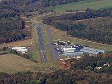
Somerset Airport (ICAO: KSMQ, FAA LID: SMQ) is a public-use airport in Somerset County, New Jersey, United States. It is located three miles (5 km) north of the central business district of Somerville and is privately owned by Somerset Air Service, Inc.[1] The airport is also known as George Walker Field.[3]
Although most U.S. airports use the same three-letter location identifier for the FAA and IATA, Somerset Airport is assigned SMQ by the FAA but has no designation from the IATA (which assigned SMQ to Sampit Airport in Indonesia).[4][5]
Facilities and aircraft
Somerset Airport covers an area of 210 acres (85 ha) which contains three runways:[1]
- Runway 12/30: 2,739 x 65 ft (835 x 20 m), Surface: Asphalt
- Runway 8/26: 1,923 x 100 ft (586 x 30 m), Surface: Turf
- Runway 17/35: 1,700 x 150 ft (518 x 46 m), Surface: Turf
For the 12-month period ending September 5, 2008, the airport had 30,339 aircraft operations, an average of 83 per day, all of which were general aviation. As of 8 January 2015, there are 121 aircraft based at this airport: 93% single-engine, and 7% multi-engine airplanes.[1]
References
- 1 2 3 4 FAA Airport Master Record for SMQ (Form 5010 PDF), effective 2015-01-08
- ↑ Somerset Airport (official site)
- ↑ Somerset Airport: History (official site)
- ↑ Great Circle Mapper: KSMQ – Somerville, New Jersey (Somerset Airport)
- ↑ Great Circle Mapper: SMQ / WAOS – Sampit, Borneo, Indonesia
External links
- FAA Terminal Procedures for SMQ, effective December 8, 2016
- Resources for this airport:
- FAA airport information for SMQ
- AirNav airport information for KSMQ
- FlightAware airport information and live flight tracker
- NOAA/NWS latest weather observations
- SkyVector aeronautical chart, Terminal Procedures