Sourdeval
| Sourdeval | |
|---|---|
 | |
 Sourdeval | |
|
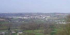
Location within Normandy region  Sourdeval | |
| Coordinates: 48°43′26″N 0°55′11″W / 48.7239°N 0.9197°WCoordinates: 48°43′26″N 0°55′11″W / 48.7239°N 0.9197°W | |
| Country | France |
| Region | Normandy |
| Department | Manche |
| Arrondissement | Avranches |
| Canton | Le Mortainais |
| Intercommunality | Le Mortainais |
| Government | |
| • Mayor (2008–2014) | Albert Bazire |
| Area1 | 51.87 km2 (20.03 sq mi) |
| Population (2013)2 | 3,154 |
| • Density | 61/km2 (160/sq mi) |
| Time zone | CET (UTC+1) |
| • Summer (DST) | CEST (UTC+2) |
| INSEE/Postal code | 50582 / 50150 |
| Elevation |
155–354 m (509–1,161 ft) (avg. 220 m or 720 ft) |
| Website | sourdeval.fr |
|
1 French Land Register data, which excludes lakes, ponds, glaciers > 1 km² (0.386 sq mi or 247 acres) and river estuaries. 2 Population without double counting: residents of multiple communes (e.g., students and military personnel) only counted once. | |
Sourdeval is a commune in the Manche department in Normandy in north-western France. On 1 January 2016, the former commune of Vengeons was merged into Sourdeval.[1]
Heraldry
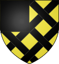 |
The arms of Sourdeval are blazoned : Or fretty sable, a canton gules. |
Twin towns
It is twinned with Odiham, a village in Hampshire.
See also
References
- ↑ Arrêté préfectoral 22/31 December 2015 (French)
| Wikimedia Commons has media related to Sourdeval. |
This article is issued from Wikipedia - version of the 4/6/2016. The text is available under the Creative Commons Attribution/Share Alike but additional terms may apply for the media files.