South Island Line (East)
South Island Line (East) 南港島綫(東段) | ||||||||||||||||||||||||||||||||||||||||||||||||||||||||||||||||||||||||||||||||||||||||||||||||||||||||||||||||||||||||||||||||||||||||||||||||||||||||||||||||||
|---|---|---|---|---|---|---|---|---|---|---|---|---|---|---|---|---|---|---|---|---|---|---|---|---|---|---|---|---|---|---|---|---|---|---|---|---|---|---|---|---|---|---|---|---|---|---|---|---|---|---|---|---|---|---|---|---|---|---|---|---|---|---|---|---|---|---|---|---|---|---|---|---|---|---|---|---|---|---|---|---|---|---|---|---|---|---|---|---|---|---|---|---|---|---|---|---|---|---|---|---|---|---|---|---|---|---|---|---|---|---|---|---|---|---|---|---|---|---|---|---|---|---|---|---|---|---|---|---|---|---|---|---|---|---|---|---|---|---|---|---|---|---|---|---|---|---|---|---|---|---|---|---|---|---|---|---|---|---|---|---|---|---|
|
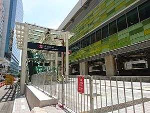
Wong Chuk Hang Station | ||||||||||||||||||||||||||||||||||||||||||||||||||||||||||||||||||||||||||||||||||||||||||||||||||||||||||||||||||||||||||||||||||||||||||||||||||||||||||||||||||
| Overview | ||||||||||||||||||||||||||||||||||||||||||||||||||||||||||||||||||||||||||||||||||||||||||||||||||||||||||||||||||||||||||||||||||||||||||||||||||||||||||||||||||
| Type | Rapid transit | |||||||||||||||||||||||||||||||||||||||||||||||||||||||||||||||||||||||||||||||||||||||||||||||||||||||||||||||||||||||||||||||||||||||||||||||||||||||||||||||||
| System | MTR | |||||||||||||||||||||||||||||||||||||||||||||||||||||||||||||||||||||||||||||||||||||||||||||||||||||||||||||||||||||||||||||||||||||||||||||||||||||||||||||||||
| Locale | Districts: Central and Western, Southern | |||||||||||||||||||||||||||||||||||||||||||||||||||||||||||||||||||||||||||||||||||||||||||||||||||||||||||||||||||||||||||||||||||||||||||||||||||||||||||||||||
| Stations | 5 | |||||||||||||||||||||||||||||||||||||||||||||||||||||||||||||||||||||||||||||||||||||||||||||||||||||||||||||||||||||||||||||||||||||||||||||||||||||||||||||||||
| Operation | ||||||||||||||||||||||||||||||||||||||||||||||||||||||||||||||||||||||||||||||||||||||||||||||||||||||||||||||||||||||||||||||||||||||||||||||||||||||||||||||||||
| Opened | Opening 2016/2017 | |||||||||||||||||||||||||||||||||||||||||||||||||||||||||||||||||||||||||||||||||||||||||||||||||||||||||||||||||||||||||||||||||||||||||||||||||||||||||||||||||
| Technical | ||||||||||||||||||||||||||||||||||||||||||||||||||||||||||||||||||||||||||||||||||||||||||||||||||||||||||||||||||||||||||||||||||||||||||||||||||||||||||||||||||
| Line length | 7 km (4.3 mi) | |||||||||||||||||||||||||||||||||||||||||||||||||||||||||||||||||||||||||||||||||||||||||||||||||||||||||||||||||||||||||||||||||||||||||||||||||||||||||||||||||
| Track gauge | 1,432 mm (4 ft 8 3⁄8 in) or 1,435 mm (4 ft 8 1⁄2 in) | |||||||||||||||||||||||||||||||||||||||||||||||||||||||||||||||||||||||||||||||||||||||||||||||||||||||||||||||||||||||||||||||||||||||||||||||||||||||||||||||||
| ||||||||||||||||||||||||||||||||||||||||||||||||||||||||||||||||||||||||||||||||||||||||||||||||||||||||||||||||||||||||||||||||||||||||||||||||||||||||||||||||||
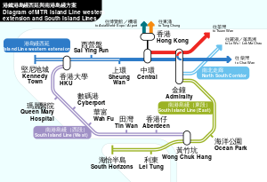
The South Island Line (East) is an extension of the Hong Kong MTR metro system. The new line will serve the southern coast of Hong Kong Island, between Ocean Park and South Horizons. Construction is expected to be completed in December 2016/February 2017. Together with the proposed South Island Line (West), these two lines connects the Southern District to the rest of the MTR network.
Stations
The following is a list of the stations on the South Island Line (East).
| Livery and name | District | Connections | Opening date | |
|---|---|---|---|---|
| South Island Line (East) | ||||
| Admiralty | Central and Western | Tsuen Wan Line, Island Line and North South Corridor (2021) | 12 February 1980[lower-alpha 1] | |
| Ocean Park | Wong Chuk Hang | 2016/2017 | ||
| Wong Chuk Hang | South Island Line (West) (proposed) | |||
| Lei Tung | Ap Lei Chau | |||
| South Horizons | ||||
Notes
- ↑ Originally opened as part of the Kwun Tong Line.
Original proposal
See also: South Island Line § Original proposal
See also
Further reading
Papers from Government and Legislature
- "Second Railway Development Study (RDS-2)" (PDF). From Highways Department Hong Kong. Retrieved 27 February 2005.
- "Information paper about the Feb 2005 scheme" (PDF). From Panel of Transport, Legislative Council. 21 February 2005. Retrieved 27 February 2005.
- "Background brief on Route 4, South Hong Kong Island Line and West Hong Kong Island Line" (PDF). From Panel of Transport, Legislative Council. 21 February 2005. Retrieved 27 February 2005.
- "Presentation of Feb 2005 scheme by MTR" (PDF). From Panel of Transport, Legislative Council. 25 February 2005. Retrieved 5 March 2005.
Press releases
- "MTR Corporation welcomes Government's decision on West Island Line and South Island Line" (PDF).. (30 June 2005). From MTR Corporation.
- http://www.mtr-southislandline.hk/pdf/press-release/26022014_pr_e.pdf
External links
| Wikimedia Commons has media related to South Island Line. |
- MTR West Island Line and South Island Line Introduction
- Papers from Legislative Council concerning West Island Line and South Island Line
| Rail service |
| ||||||||||||||||||||||||||||
|---|---|---|---|---|---|---|---|---|---|---|---|---|---|---|---|---|---|---|---|---|---|---|---|---|---|---|---|---|---|
| Non-rail service |
| ||||||||||||||||||||||||||||
| |||||||||||||||||||||||||||||
Public transportation in Eastern Pearl River Delta | |||||||||||
|---|---|---|---|---|---|---|---|---|---|---|---|
| Shenzhen Metro |
| ||||||||||
| Dongguan Rail Transit |
| ||||||||||
| Hong Kong MTR |
| ||||||||||
| Other Urban Rails/Cableways |
| ||||||||||
| Intercity Rails (PRD-RT) |
| ||||||||||
| Transportation Hubs |
| ||||||||||
| |||||||||||
This article is issued from Wikipedia - version of the 11/24/2016. The text is available under the Creative Commons Attribution/Share Alike but additional terms may apply for the media files.