South Main and Washington Streets Historic District
|
South Main and Washington Streets Historic District | |
|
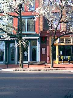
Buildings along Washington Street, April 2009 | |
  | |
| Location |
68-139 Washington St. and 2-24 S. Main St., (original) 11-15 through 54-60 S. Main St., (increase I) Roughly along N. Main St. from Washington St. to Ann St. (increase II) Norwalk, Connecticut |
|---|---|
| Coordinates | 41°5′55″N 73°24′22″W / 41.09861°N 73.40611°WCoordinates: 41°5′55″N 73°24′22″W / 41.09861°N 73.40611°W |
| Area |
5.5 acres (2.2 ha) (original) 2.5 acres (1.0 ha) (first increase) 3 acres (1.2 ha) (second increase) |
| Built | 1870 |
| Architectural style |
Second Empire, Romanesque, Italianate (original) Late 19th And 20th Century Revivals, Late Victorian (increase I) Late Victorian, Late 19th And 20th Century Revivals (increase II) |
| NRHP Reference # |
77001393 (original) 85003505 (increase 1) 99000449[1] (increase 2) |
| Significant dates | |
| Added to NRHP | December 16, 1977 |
| Boundary increases |
November 8, 1985 April 15, 1999 (increase II) |
The South Main and Washington Streets Historic District — 68-139 Washington St. and 2-24 South Main St. is a historic district in South Norwalk, Connecticut. The 110-acre (45 ha) district encompasses 35 buildings and two other structures (including the South Norwalk Railroad Bridge). Varied architectural styles from the late 19th and early 20th centuries include Romanesque Revival, Second Empire, and Italianate architecture. Half (5.5 acres (2.2 ha)) of the area first became part of the National Register of Historic Places in 1977 (35 buildings and two structures). The district was increased in 1985 with the addition of nine buildings on 2.5 acres (1.0 ha) (11-15 through 54-60 South Main St.) and again in 1999, with another 10 buildings on 3 acres (1.2 ha), roughly along North Main Street from Washington Street to Ann Street.[2]
The original district included 26 contributing buildings and 2 other contributing structures over a 5.5-acre (2.2 ha) area. The district was first increased to add 9 contributing buildings over a 2.5-acre (1.0 ha) area. The second increase added 10 contributing buildings over a 3-acre (1.2 ha) area.[1] The district is a densely packed area, with an 1895 railroad bridge at its "visual center". Its "primary significance" is as "an extensive and cohesive collection of late 19th century and early 20th century commercial structures."[3]
See also
References
- 1 2 National Park Service (2009-03-13). "National Register Information System". National Register of Historic Places. National Park Service.
- ↑ Title 36: Section 60.3, Parks Forests and Public Property, Chapter One, Part 60. National Register of Historic Places. Retrieved February 19, 2007.
- ↑ Bruce Clouette (March 28, 1977). "National Register of Historic Places Inventory-Nomination: South Main & Washington Street" (PDF). National Park Service. and Accompanying 13 photos, from 1977
