South Sauty Creek
| South Sauty Creek | |
| Country | United States |
|---|---|
| State | Alabama |
| Regions | DeKalb County, Jackson County, Marshall County |
| Source | |
| - location | near Henagar in DeKalb County, Alabama, United States |
| - elevation | 1,600 ft (488 m) |
| - coordinates | 34°38′11″N 085°43′31″W / 34.63639°N 85.72528°W [1] |
| Mouth | Guntersville Lake of the Tennessee River |
| - location | near Langston, Alabama in Jackson County, Alabama, United States |
| - elevation | 594 ft (181 m) [1] |
| - coordinates | 34°32′35″N 086°07′17″W / 34.54306°N 86.12139°WCoordinates: 34°32′35″N 086°07′17″W / 34.54306°N 86.12139°W [1]
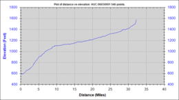 Elevation Profile vs River Length
|
| Length | 32.25 mi (52 km) |
| Basin | 125.8 sq mi (326 km2) |
South Sauty Creek is 32.25 miles (51.90 km) long[2] with a drainage area of 125.8 square miles (326 km2),[2] and is a tributary to the Tennessee River. The river rises in DeKalb County, Alabama, and flows generally southwest along Sand Mountain from its headwaters before turning generally west and flowing off of Sand Mountain, through Buck’s Pocket, terminating shortly afterwards into Lake Guntersville in an area known as Morgan's Cove.[3] South Sauty forms the Buck’s Pocket canyon as the creek falls from the north side of Sand Mountain (Alabama).
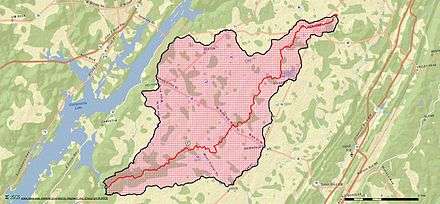
Drainage Basin Map
References
- 1 2 3 U.S. Geological Survey Geographic Names Information System: South Sauty Creek. Accessed 2015-01-07.
- 1 2 "Alabama StreamStats". U.S. Geological Survey. Retrieved 2015-01-07.
- ↑ "Buck's Pocket State Park". Alabama State Parks. Retrieved 2015-01-07.
This article is issued from Wikipedia - version of the 9/10/2016. The text is available under the Creative Commons Attribution/Share Alike but additional terms may apply for the media files.