Southwark St Saviour
| Southwark St Saviour | |
|---|---|
 | |
| Area | |
| • 1881 | 127 acres (0.51 km2) |
| • 1901 | 132 acres (0.53 km2) |
| • 1921 | 133 acres (0.54 km2) |
| Population | |
| • 1881 | 14,999 |
| • 1901 | 12,056 |
| • 1921 | 9,007 |
| History | |
| • Origin | St Margaret and St Mary Magdeline |
| • Created | 1541 |
| • Abolished | 1930 |
| Status | Civil parish |
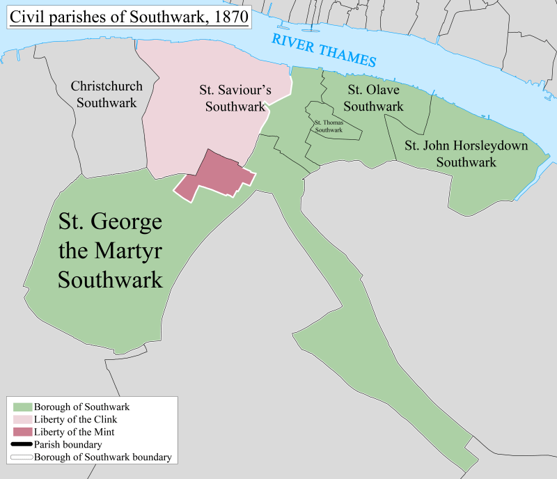
Southwark (Br [ˈsʌðɨk])[1] St Saviour was a civil parish in the metropolitan area of London, England, and part of the ancient Borough of Southwark. It was formed in 1541 from the union of the parishes of St Margaret and St Mary. It was abolished in 1930, however residents of the former parish receive a rebate against local taxation because of the presence of Borough Market.
Administration
It was created in 1541 from the former area of the parishes of St Margaret and St Mary Magdalene. In 1855 it was grouped with Southwark Christchurch into the St Saviour's District of the Metropolis. It became part of the County of London in 1889. The Saviour's District was abolished in 1900 and Southwark St Saviour became part of the Metropolitan Borough of Southwark. The parish was absorbed by Southwark in 1930.[2]
Borough Market
The parish contained the large wholesale food market Borough Market. The trustees of the market have been appointed by the parish since 1756. Additionally, any profit from the operation of the market must be repaid to the local authority and used to offset local taxation. This arrangement has outlasted the abolition of the parish in 1930 and council tax payers in the former parish receive a rebate against their Council Tax.[3]
Geography
To the north the parish had a long boundary fronting the River Thames and the City of London. It stretched, in modern terms, to include the whole of the Bankside Power Station in the west and fell just short of London Bridge station in the east. Half of the current site of Guy's Hospital was within the parish, with Great Maze Pond broadly marking the boundary with St Olave. Parts of what is now Newcomen Street, Little Dorrit Court and Southwark Bridge Road broadly marked the irregular southern boundary with St George the Martyr parish. In the west there was a boundary with Southwark Christchurch (formerly the liberty of Paris Garden) that followed, but fell short of, what is now Great Suffolk Street, Sumner Street, and Holland Street.
References
- ↑ "Southwark", in The Columbia Lippincott Gazetteer of the World (1952), New York: Columbia University Press.
- ↑ Youngs, Frederic (1979). Guide to the Local Administrative Units of England. I: Southern England. London: Royal Historical Society. ISBN 0-901050-67-9.
- ↑ "Appointment of Trustees to the Borough Market, Southwark" (PDF). Southwark London Borough Council. 31 March 2004. Retrieved 7 September 2010.
Coordinates: 51°30′26″N 0°5′40″W / 51.50722°N 0.09444°W