Sowood, West Yorkshire
| Sowood | |
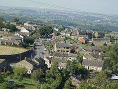 View over Sowood from Sowood Hill. Part of Stainland, Norland Moor and the wind turbines at Ovenden Moor can be seen. |
|
 Sowood |
|
| OS grid reference | SE079184 |
|---|---|
| Metropolitan borough | Calderdale |
| Metropolitan county | West Yorkshire |
| Region | Yorkshire and the Humber |
| Country | England |
| Sovereign state | United Kingdom |
| Post town | HALIFAX |
| Postcode district | HX4 |
| Dialling code | 01422 |
| Police | West Yorkshire |
| Fire | West Yorkshire |
| Ambulance | Yorkshire |
| EU Parliament | Yorkshire and the Humber |
| UK Parliament | Calder Valley |
Coordinates: 53°39′43″N 1°52′51″W / 53.662045°N 1.880791°W
Sowood is a village in Calderdale, West Yorkshire, England. The village falls within the Greetland and Stainland ward of Calderdale Council. It is 4.5 miles (7.2 km) south of Halifax, 4 miles (6.4 km) north-west of Huddersfield and 2.5 miles (4.0 km) south-west of Elland.
Geography
Sowood is one of the highest places in Calderdale, standing at 280 metres (920 ft) above sea level. The main road that passes through the village is the B6112, which links the village with Stainland, Greetland, and Outlane. It is very close to the Calderdale and Kirklees district boundary.
External links
![]() Media related to Sowood, West Yorkshire at Wikimedia Commons
Media related to Sowood, West Yorkshire at Wikimedia Commons
This article is issued from Wikipedia - version of the 2/24/2016. The text is available under the Creative Commons Attribution/Share Alike but additional terms may apply for the media files.