St. Marys Historic District (Georgia)
|
St. Marys Historic District | |
|
| |
  | |
| Location | Roughly bounded by Waterfront Rd., Norris, Alexander, and Oak Grove Cemetery. St. Marys, Georgia |
|---|---|
| Coordinates | 30°44′36″N 81°31′24″W / 30.74333°N 81.52333°WCoordinates: 30°44′36″N 81°31′24″W / 30.74333°N 81.52333°W |
| Area | 230 acres (93 ha) |
| Built | mid-1500s |
| Architectural style | Gothic, Queen Anne, et al. |
| NRHP Reference # | 76000609[1] |
| Added to NRHP | May 13, 1976 |
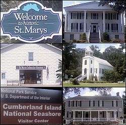
St. Marys Historic District was listed on the National Register of Historic Places on May 13, 1976[1][2] and is located in St. Marys, Georgia. The city was first settled in the mid-16th century by the Spanish.
Historical significance
The St. Marys historic district is roughly bounded by Waterfront Rd., Norris Alexander, and Oak Grove Cemetery, c. 1787. Contains portions of the original 18th-century town containing residential, commercial, and religious buildings dating from the late 18th-early 20th century. Notable features include the waterfront area, early cemetery, bell cast by Paul and Joseph Warren Revere, and a memorial oak planted the day of George Washington's burial. It was an important early port city, first settled in the mid-16th century by the Spanish and a haven for expelled French Huguenots in the 18th century.Established by an act of the state legislature on December 5, 1792 and was incorporated in November 1802. It served as Camden County Georgia's seat of government from 1869 until 1923.[3]
Gallery of photos
 Orange Hall c.1838 |
 Jackson-Clark-Bessent-MacDonell-Nesbitt House c.1801 |
 First Presbyterian Church c.1808 |
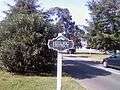 St. Marys Historic District sign |
See also
- St. Marys, Georgia
- Cumberland Island
- National Register of Historic Places listings in Camden County, Georgia
References
- 1 2 National Park Service (2009-03-13). "National Register Information System". National Register of Historic Places. National Park Service.
- ↑ http://www.nationalregisterofhistoricplaces.com/ga/Camden/state.html
- ↑ http://www.georgiaencyclopedia.org/nge/Article.jsp?id=h-2219
External links
- St Marys Downtown Development Authority
- St. Marys Convention and Visitors Bureau
- Georgia's Coast in photographs and more
External links
![]() Media related to St. Marys Historic District at Wikimedia Commons
Media related to St. Marys Historic District at Wikimedia Commons
| Topics | |
|---|---|
| Lists by states |
|
| Lists by insular areas | |
| Lists by associated states | |
| Other areas | |
| |