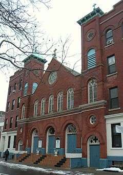
St. Pius V's Church (Bronx)
| The Church of St. Pius V | |
|---|---|
 | |
| General information | |
| Town or city | Mott Haven, the Bronx, New York |
| Country | United States |
| Construction started | 1906 |
| Completed | 1907[1] |
| Client | Roman Catholic Archdiocese of New York |
| Technical details | |
| Structural system | Red brick masonry |
| Design and construction | |
| Architect | Anthony F. A. Schmitt[1] |
The Church of St. Pius V is a Roman Catholic parish church under the authority of the Roman Catholic Archdiocese of New York, located at 416-418, 420 East 145th Street, in the North New York neighborhood of the Bronx in New York City, in the U.S. state of New York. The parish was established in 1906.[2]
Building
The red-brick church was built in 1906-1907 to the designs by Anthony F. A. Schmitt.[1] In 1914, the property was valued at $125,000[2] The primary Pastor of this Parish is Father Salcero Osiris.
St. Pius V Girls' High School
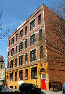
School
"A 'fine' school was opened September 1913."[2] The parish school was among 27 closed by Archbishop Dolan in the Archdiocese of New York on 11 January 2011.[3][4]
References
- 1 2 3 White, Norval; Willensky, Elliot; Leadon, Fran (2010). AIA Guide to New York City. American Institute of Architects New York Chapter (Fifth ed.). Oxford: Oxford University Press. p. 823. ISBN 978-0-19-538386-7.
- 1 2 3 Remigius Lafort, S.T.D., Censor, The Catholic Church in the United States of America: Undertaken to Celebrate the Golden Jubilee of His Holiness, Pope Pius X. Volume 3: The Province of Baltimore and the Province of New York, Section 1: Comprising the Archdiocese of New York and the Diocese of Brooklyn, Buffalo and Ogdensburg Together with some Supplementary Articles on Religious Communities of Women.. (New York City: The Catholic Editing Company, 1914), p.392.
- ↑ Alice McQuillan, "New York Archdiocese to Close 27 Schools," NBC New York, 11 January 2011 (Accessed 7 February 2011)
- ↑ Archdiocese of New York, "RECONFIGURATION COMMITTEE RECOMMENDATIONS REGARDING “AT-RISK” SCHOOLS ACCEPTED BY ARCHDIOCESE OF NEW YORK," Official Press Release, 11 January 2011 (Accessed 7 February 2011)
Coordinates: 40°48′47″N 73°55′8.4″W / 40.81306°N 73.919000°W
This article is issued from Wikipedia - version of the 11/12/2016. The text is available under the Creative Commons Attribution/Share Alike but additional terms may apply for the media files.