St Clement Danes (parish)
| St Clement Danes | |
|---|---|
| Civil parish | |
 | |
| Area | |
| • 1881 | 53 acres (0.21 km2) |
| • 1901/1921 | 57 acres (0.23 km2) |
| • Coordinates | 51°30′50″N 0°06′57″W / 51.5138°N 0.1158°WCoordinates: 51°30′50″N 0°06′57″W / 51.5138°N 0.1158°W |
| Population | |
| • 1881 | 10,280 |
| • 1901 | 6,090 |
| • 1921 | 1,905 |
| Density | |
| • 1881 | 194/acre |
| • 1901 | 107/acre |
| • 1921 | 33/acre |
| History | |
| • Origin | Ancient parish |
| • Created | 10th century |
| • Abolished | 1922 |
| • Succeeded by | City of Westminster (parish) |
| Status | Civil parish |
| Government |
St Clement Danes Vestry (16th century–1855) |
| • Type | Vestry |
| • HQ | Vestry Hall, Strand |
| Contained within | |
| • District | Strand (1855–1900) |
| • Poor Law Union |
Strand (1836–1913) City of Westminster (1913–1922) |
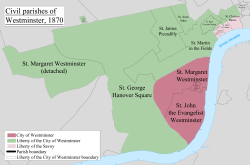
St Clement Danes was a civil parish in the metropolitan area of London, England. The parish was split between the Liberty of Westminster and the Liberty of the Duchy of Lancaster. Much of the former parish is now occupied by the site of the London School of Economics and the Strand, in the extreme southeast of the City of Westminster.
Toponymy

It took its name from the dedication of the church of St Clement Danes. It is recorded in the early 12th century as parochia Sancti Clementis ecclesie Dacorum or 'the parish of St Clement's church of the Danes'. The name suggests there were Danes living in the area, to the west of the City of London.[1]
History and Governance
It was an ancient parish and was partly within the Liberty of Westminster and partly within the Ossulstone hundred of Middlesex.[2] The Ossulstone section formed part of the Liberty of the Duchy of Lancaster. The parish was included in the returns of the Bills of mortality from 1604.[3]
In 1826 the stocks belonging to the parish, situated in Portugal Street were removed and destroyed. They were thought to be the last remaining in London.[4]
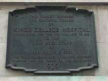
King's College Hospital was originally opened in 1840 in the disused St Clement Danes parish workhouse in Portugal Street, as a training facility where medical students of King's College London could practice and receive instruction from the college's own professors. The surrounding area there was composed of overcrowded slums characterised by poverty and disease and the hospital was treating 1,290 inpatients in 120 beds, with two patients sharing a bed by no means unusual.[5] The parish was grouped into the Strand District in 1855 when it came within the area of responsibility of the Metropolitan Board of Works. In 1889 the parish became part of the County of London and in 1900 it became part of the Metropolitan Borough of Westminster. Before the community was abolished as a civil parish in 1922, the Hospital has already moved to its present site in Denmark Hill.
Geography
The parish consisted of two separate sections, both fronting the River Thames.
The main part was in the east adjacent to the Liberty of the Rolls and the The Temple area of the City of London. To the west it had a boundary with St Mary le Strand. To the north it was bounded by St Martin in the Fields and in the west the boundary was with St Giles in the Fields.
The western detached part was located between the Precinct of the Savoy and the parish of St Martin in the Fields.[6]
References
- ↑ Mills, D. (2000). Oxford Dictionary of London Place Names. Oxford.
- ↑ Youngs, Frederic (1979). Guide to the Local Administrative Units of England. I: Southern England. London: Royal Historical Society. ISBN 0-901050-67-9.
- ↑ Reginald H. Adams (1971). The Parish Clerks of London. Phillimore.
- ↑ Richardson, John (2000). The annals of London : a year-by-year record of a thousand years of history. Berkeley: University of California Press. ISBN 0520227956.
- ↑ "Charles Lucas".
- ↑ Port, M. H. (Edr.) (1986). "Illustrative map of London parishes". The Commissions for building fifty new churches: The minute books, 1711-27, a calendar. London Record Society.
External links
History of the formation of the City of Westminster | ||
|---|---|---|
| Metropolitan boroughs |  | |
| District boards | ||
| Parishes | ||
| Liberties | ||