St James's Place
Not to be confused with St. James's Palace.
This article is about the street. For the wealth management business, see St. James's Place Wealth Management Group.

No. 4 St James's Place, from where Frédéric Chopin left for the Guildhall on 16 November 1848 for his last public performance.

St James's Street and sign for St James's Place
St James's Place is a street in the St James's district of London near Green Park.[1] It was first developed around 1694, the historian John Strype describing it in 1720 as a "good Street ... which receiveth a fresh Air out of the Park; the Houses are well-built, and inhabited by Gentry ..."[2][3] Henry Benjamin Wheatley wrote in 1870 that it was "one of the oddest built streets in London."[3]
Spencer House, which was commissioned by the first Earl Spencer in 1756, stands at number 27 and is now listed as Grade I.[4][5] A further thirteen properties are Grade II listed, as are three bollards and seven lamp standards; Number 4 is Grade II* listed.[6]
Notable residents
- Joseph Addison (1672–1719), the author and politician who founded The Spectator, lived here in 1710.[3]
- Eustace Budgell (1686–1737), English writer and politician[3]
- Sir Francis Burdett (1770–1844), the reforming politician known as "Old Glory", lived at number 25 from 1820 to 1844.[7]
- James Craggs the Younger (1686–1721), English politician[3]
- Mary Delany (1700–1788), English artist and writer[3]
- Henry Grattan (1746–1820), Irish politician[3]
- White Kennett (1660–1728), Bishop of Peterborough[3]
- John Lubbock[3]
- Richard Rigby (1722-1788), English civil servant and politician[3]
- Samuel Rogers (1763–1855), 19th-century English poet[8]
- John Wilkes (1725–1797), English journalist and politician, lived there in 1756.[3]
- St. James's Place images
 Francis Chichester Map and Guide publishing house At 9 St James's Place
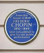 Sign at 4 St James's Place, marked as the location of Frédéric Chopin's last public performance
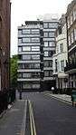 26 St James's Place
See also
References
- ↑ St James's Street, londontown.com, accessed 23 April 2012.
- ↑ Stow, John. "Southwark, and Parts Adjacent", A Survey of the Cities of London and Westminster, Borough of Southwark and Parts Adjacent, p. 663.
- Also see "St James's Park," The Parish of St. James Westminster. Part II: north of Piccadilly, Volumes 31-32 of Survey volumes, Athlone Press, University of London, 1963, p. 511ff.
- 1 2 3 4 5 6 7 8 9 10 11 Henry Benjamin Wheatley (1870), Round about Piccadilly and Pall Mall, Smith, Elder & co., pp. 167–169
- ↑ Ed Glinert (2004), "St. James's Place", The London Compendium, Penguin UK, ISBN 9780141012131
- ↑ "The National Heritage List for England: SPENCER HOUSE". English Heritage. Retrieved 24 April 2012.
- ↑ "The National Heritage List for England (search term: st james's place sw1)". English Heritage. Retrieved 24 April 2012.
- ↑ "Burdett, Sir Francis", The History of Parliament, accessed 24 April 2012.
- ↑ Richard Ellis Roberts (1910), "St. James's Place", Samuel Rogers and his circle, Dutton, p. 48
External links
-
 Media related to St James's Place, London at Wikimedia Commons
Coordinates: 51°30′19″N 0°8′24″W / 51.50528°N 0.14000°W
This article is issued from Wikipedia - version of the 10/16/2016. The text is available under the Creative Commons Attribution/Share Alike but additional terms may apply for the media files.