St Johns railway station
| St Johns | |
|---|---|
 | |
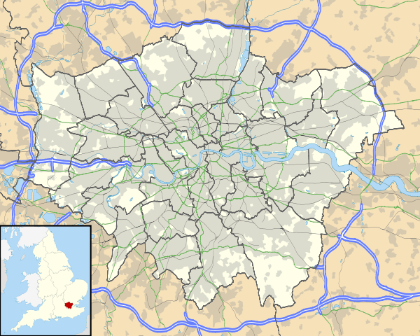 St Johns Location of St Johns in Greater London | |
| Location | St Johns |
| Local authority | London Borough of Lewisham |
| Managed by | Southeastern |
| Station code | SAJ |
| DfT category | E |
| Number of platforms | 2 |
| Fare zone | 2 |
| National Rail annual entry and exit | |
| 2007–08 |
|
| 2008–09 |
|
| 2009–10 |
|
| 2010–11 |
|
| 2011–12 |
|
| 2012–13 |
|
| Key dates | |
| 1 June 1873 | Opened |
| Other information | |
| Lists of stations | |
| External links | |
| WGS84 | 51°28′09″N 0°01′21″W / 51.4691°N 0.0225°WCoordinates: 51°28′09″N 0°01′21″W / 51.4691°N 0.0225°W |
|
| |
St Johns railway station is on the South Eastern Main Line in the United Kingdom, located in the London Borough of Lewisham, in south-east London. It is 5 miles 47 chains (9.0 km) down-line from London Charing Cross and is situated between New Cross and Lewisham.
History
Early years (1873-1922)
Although the South Eastern Railway(SER) opened a two-track railway (the North Kent Railway) through the site of St Johns (although the church that gave the station its name was not built until 1855)in 1849, and two further tracks were added in 1864, the station was opened on 1 June 1873.[2] The SER was at that time engaged in a bitter feud with the London Chatham and Dover Railway (LCDR) who opened a station (adjacent to the church) called Lewisham Road as part of the initial section of the Greenwich Park branch in 1871 and this, coupled with the development of the area, may have been a factor in the building of the station.[3]
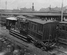
On 21 March 1898, two trains collided in thick fog, killing three people, when a signaller allowed a train to enter the station while another train was at the platform.[4][5]
In 1899 the South Eastern Railway and the London Chatham and Dover Railway agreed to work as one railway company under the name of the South Eastern and Chatham Railway.
In 1906 an additional two lines were added south of St Johns towards Hither Green with a new junction located immediately south of the station. In addition to the existing signal box which was located on the north end of the platform s second box was provided between the North Kent lines and main lines close to the new junction.
Southern Railway (1923-1947)
Following the Railways Act 1921 (also known as the Grouping Act), St Johns became a Southern Railway station on 1 January 1923.
The main line was electrified in February 1926 for the operation of electric services to Cannon Street or Charing Cross to Orpington. and was electrified with the (750 V DC third rail) system. The following year the bridge carrying the Greenwich Park Branch which closed in 1917 was removed in anticipation of the opening of the Nunhead- Lewisham line which saw a new bridge provided and the line opening in 1929. The two signal boxes at St Johns were closed and a new box opened just south of the station on the east side of the line.[6]
British Railways (1948-1994)
On 1 January 1948 following nationalisation the station passed to British Railways Southern Region.
On 4 December 1957, two trains collided just south-east of the station on the main line bypassing Lewisham, bringing down the Lewisham-Nunhead railway bridge and killing 90 people. Further disaster was averted as a train about to cross the bridge was halted by its driver.
In the mid 1970s the station was re-modelled when the fast line island platform was closed and demolished. This provided space to build a flydown from the Lewisham-Nunhead line to the up fast line.
The booking office at street level was destroyed by fire in the late 1970s.
Upon sectorisation in 1982, three passenger sectors were created: InterCity, operating principal express services; and London & South East (renamed Network SouthEast in 1986) who operated commuter services in the London area.[7]
The privatisation era (1994-Present Day)
Following privatisation of British Rail on 1 April 1994 the infrastructure at St Johns station became the responsibility of Railtrack whilst a business unit operated the train services. On 13 October 1996 operation of the passenger services passed to Connex South Eastern who were originally due to run the franchise until 2011.
Following a number of accidents and financial issues Railtrack plc was sold to Network Rail on 3 October 2002 who became responsible for the infrastructure.[8][9]
On 27 June 2003 the Strategic Rail Authority decided to strip Connex of the franchise citing poor financial management and run the franchise itself.[10][11] Connex South Eastern continued to operate the franchise until 8 November 2003 with the services transferring to the Strategic Rail Authority's South Eastern Trains subsidiary the following day.
On 30 November 2005 the Department for Transport awarded Govia the Integrated Kent franchise. The services operated by South Eastern Trains transferred to Southeastern on 1 April 2006.
Layout
As built the station had two island platforms and an additional terminating platform on the west side of the line although it is doubtful this was ever used in regular traffic.[12]
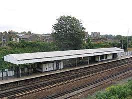
Today (in 2015) the station is reached by a footbridge from St Johns Vale - there is no direct road access. A single island platform with two platform faces remains located on the slow lines.
South of the station the former Greenwich Park branch crossed over before closure in 1917. The line from Nunhead lay dormant until a bridge was provided and the line was connected to Lewisham in 1929. The remains of the embankment can be seen on the eastern side of the line. There was a signal box at the south end of the station that closed and was demolished when the area was resignalled in the mid 1970s. The flydown was built at this time and commissioned on 3 April 1976.[13]
In the early 1990s the original bridge carrying St Johns Vale was replaced. This allowed the platforms to be extended towards New Cross to allow longer trains to call.
It was proposed to double the flydown line under the Thameslink Programme. Work started in 2012 with cranes and civil engineering plant on site on 8 April;[14] it was completed over Easter 2013.
| Preceding station | |
Following station | ||
|---|---|---|---|---|
| New Cross | Southeastern Grove Park Line, Hayes Line and Dartford Loop Line |
Lewisham | ||
References
- 1 2 3 4 5 6 "Station usage estimates". Rail statistics. Office of Rail Regulation. Please note: Some methodology may vary year on year.
- ↑ Butt, R.V.J. (1995). The Directory of Railway Stations. Yeovil: Patrick Stephens Ltd. p. 203. ISBN 1-85260-508-1. R508.
- ↑ Accidents and Islands: A History of St Johns Station – Part 1, London Reconnections
- ↑ Board of Trade (8 April 1898). Report into the accident at St Johns station in 1898.
- ↑ Pedantic of Purley (25 April 2013). Accidents and Islands: A History of St Johns Station – Part 1, London Reconnections
- ↑ Pedantic of Purley (25 April 2013). Accidents and Islands: A History of St Johns Station – Part 1, London Reconnections
- ↑ Thomas, David St John; Whitehouse, Patrick (1990). BR in the Eighties. Newton Abbot: David & Charles. ISBN 0-7153-9854-7.
- ↑ Network Rail closer to Railtrack takeover BBC News, 1 April 2016
- ↑ "Accounting for Producer Needs: The case of Britain's rail infrastructure" (PDF). Centre for Management and Organisational History. p. 18. Retrieved 1 April 2016.
- ↑ "BBC NEWS - UK - England - Train firm loses franchise". BBC News. 27 June 2003. Retrieved 1 April 2016.
- ↑ Basher Bowker pulls the plug on Connex The Telegraph 29 June 2003
- ↑ Pedantic of Purley (25 April 2013). Accidents and Islands: A History of St Johns Station – Part 1, London Reconnections
- ↑ London's Local Railways A A JACKSON ISBN 1-85414-209-7
- ↑ Modern Railways May 2012 Page 86
External links
| Wikimedia Commons has media related to St John's railway station. |
- Accident at Lewisham on 4 December 1957 (Summary)
- Report On The Collision That Occurred On 4 December 1957 Near Lewisham In The Southern Region British Railways (2.2 Mb)
Railways around Lewisham and Hither Green | ||||||||||||||||||||||||||||||||||||||||||||||||||||||||||||||||||||||||||||||||||||||||||||||||||||||||||||||||||||||||||||||||||||||||||||||||||||||||||||||||||||||||||||||||||||||||||||||||||||||||||||||||||||||||||||||||||||||||||||||||||||||||||||||||||||||||||||||||||||||||||||||||||||||||||||||||||||||||||||||||||||||||||||||
|---|---|---|---|---|---|---|---|---|---|---|---|---|---|---|---|---|---|---|---|---|---|---|---|---|---|---|---|---|---|---|---|---|---|---|---|---|---|---|---|---|---|---|---|---|---|---|---|---|---|---|---|---|---|---|---|---|---|---|---|---|---|---|---|---|---|---|---|---|---|---|---|---|---|---|---|---|---|---|---|---|---|---|---|---|---|---|---|---|---|---|---|---|---|---|---|---|---|---|---|---|---|---|---|---|---|---|---|---|---|---|---|---|---|---|---|---|---|---|---|---|---|---|---|---|---|---|---|---|---|---|---|---|---|---|---|---|---|---|---|---|---|---|---|---|---|---|---|---|---|---|---|---|---|---|---|---|---|---|---|---|---|---|---|---|---|---|---|---|---|---|---|---|---|---|---|---|---|---|---|---|---|---|---|---|---|---|---|---|---|---|---|---|---|---|---|---|---|---|---|---|---|---|---|---|---|---|---|---|---|---|---|---|---|---|---|---|---|---|---|---|---|---|---|---|---|---|---|---|---|---|---|---|---|---|---|---|---|---|---|---|---|---|---|---|---|---|---|---|---|---|---|---|---|---|---|---|---|---|---|---|---|---|---|---|---|---|---|---|---|---|---|---|---|---|---|---|---|---|---|---|---|---|---|---|---|---|---|---|---|---|---|---|---|---|---|---|---|---|---|---|---|---|---|---|---|---|---|---|---|---|---|---|---|---|---|---|---|---|---|---|---|---|---|---|---|---|---|---|---|---|---|---|---|---|
Legend
| ||||||||||||||||||||||||||||||||||||||||||||||||||||||||||||||||||||||||||||||||||||||||||||||||||||||||||||||||||||||||||||||||||||||||||||||||||||||||||||||||||||||||||||||||||||||||||||||||||||||||||||||||||||||||||||||||||||||||||||||||||||||||||||||||||||||||||||||||||||||||||||||||||||||||||||||||||||||||||||||||||||||||||||||
| Companies and organisations | |||||||||||
|---|---|---|---|---|---|---|---|---|---|---|---|
| Airports |
| ||||||||||
| Major stations | |||||||||||
| Roads |
| ||||||||||
| Ticketing | |||||||||||
| Other | |||||||||||
| Former BR sectors | |||||||||||
| |||||||||||