Stamford Hill
| Stamford Hill | |
_-_geograph.org.uk_-_169793.jpg) |
|
 Stamford Hill |
|
| Area | 5.2 km2 (2.0 sq mi) |
|---|---|
| Population | 68,050 [1] |
| – density | 13,087/km2 (33,900/sq mi) |
| OS grid reference | TQ335875 |
| – Charing Cross | 5.5 mi (8.9 km) SSW |
| London borough | |
| Ceremonial county | Greater London |
| Region | London |
| Country | England |
| Sovereign state | United Kingdom |
| Post town | LONDON |
| Postcode district | N15, N16, E5 |
| Dialling code | 020 |
| Police | Metropolitan |
| Fire | London |
| Ambulance | London |
| EU Parliament | London |
| UK Parliament | Hackney North and Stoke Newington |
| London Assembly | |
Coordinates: 51°34′14″N 0°04′22″W / 51.5705°N 0.0727°W
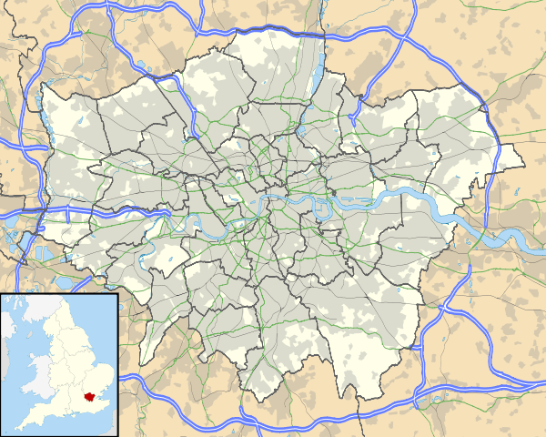
Stamford Hill is a district in north London, England.
The area is known for its Hasidic community,[2] the largest concentration of Haredi Jews in Europe. Due to their high fertility, the area has one of highest birthrates in the UK, with a crude birth rate of more than 25 per 1,000 of the population, twice the UK average.[3]
Stamford Hill is also the name of part of the A10 road running through the area from Stoke Newington High Street to the start of Tottenham High Road.
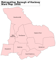
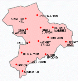
Boundaries
Informal boundaries
The more usual, and loose, definition is centred on the physical feature of the hill and the neighbourhood’s location within the Ancient Parish and subsequent (with almost identical boundaries) Metropolitan Borough of Hackney. The association of Stamford Hill with part of the N16 postcode district is also useful in describing its extent.
Northern boundary with Tottenham: Takes the northern boundary of the AP\MB of Hackney. This corresponds to the current boundary between the modern borough of Hackney and Haringey.
Western boundary with Stoke Newington: Takes part of the AP\MB of Hackney’s boundary with the AP\MB of Stoke Newington along Bethune Road and down to the A10.
Southern Boundary with Stoke Newington: This boundary is very ill defined, partly because Stoke Newington has unofficially grown beyond the AP\MB of Stoke Newington; extending its sphere of self-identification east of the A10 to overlap and become dominant in areas of the former AP\MB of Hackney.
Both Stamford Hill and Stoke Newington are closely identified with the N16 postcode so there are no postcode boundaries to make a distinction, and hence the location of Stoke Newington station at the foot of the hill itself, is perhaps the only real guideline in determining where Stamford Hill and Stoke Newington meet and overlap.
East and south-east boundary with Upper Clapton: Upper Clapton shares much of the eastern side of the hill itself and the distinction between the two districts can be closely, though not quite exactly based on the boundary between the N16 Postal area to which Stamford Hill belongs, and the E5 postal area to which Upper Clapton belongs.
Broader, formalised definition
The London Borough of Hackney agreed a ‘Designation of Neighbourhood Area’ for Stamford Hill covering four wards in the London Borough of Hackney (Cazenove, Woodberry Downs, Stamford Hill West and Springfield), and one ward in Haringey (Seven Sisters).[4]
Since this designation was made the Hackney Wards have been abolished or their boundaries redrawn. This designation includes areas usually seen as parts of Stoke Newington, Upper Clapton and Tottenham, however this is not as contradictory as it first appears as the boundaries between London districts are often ill-defined and overlapping.
History
Stamford Hill lies on the old Roman road of Ermine Street, on high ground above Stoke Newington, where it crosses the road from the medieval village of Clopton (the modern Upper and Lower Clapton) into Hackney. By the 18th century, the road was subject to heavy traffic, including goods wagons pulled by six or more horses, and this caused the surface of the road to deteriorate. The local parishes appealed to Parliament in 1713 for the right to set up a Turnpike Trust, to pay for repairs and maintenance. Gates were installed at Kingsland and Stamford Hill to collect the tolls.[5]
Development of the area began around 1800, and many prosperous dwellings were built around Stamford Hill over the next 100 years. The London Road became a busy commercial centre to serve the needs of the burgeoning population. Around 1880, not only were railways serving the area, but this was the point where the tram systems coming north from the city[6] met the Hackney tram system,[7] and so it became a busy interchange, with a depot opening in 1873.[8] Electrification commenced in 1902 and by 1924 a service was commenced between Stamford Hill and Camden Town along Amhurst Park.
Stamford Hill had many eminent Jewish residents, including the Montefiore family. Italian-born Moses Vita Montefiore (died 1789) was living there in 1763. His son Joseph (died 1804) married Rachel Mocatta, and his grandson Abraham Montefiore (died 1824) married Henrietta whose father, the financier Nathan Meyer Rothschild, lived near the modern Colberg Place from 1818 to 1835. The Montefiores' property a little further south was to be transformed by Abraham's grandson, Claude Montefiore, into Montefiore House school. With the increased development of the area, many distinguished families moved away: in 1842 there were few remaining of the wealthy Jews who had once settled in Hackney.[9] The philanthropist and abolitionist MP Samuel Morley had a residence here from about 1860. The gardening writer and cottage gardener Margery Fish was born Margery Townshend in Stamford Hill in 1892.[10]
From the 1880s, a new influx of Jews arrived in the area escaping from the poverty of Stepney in the East End[11] and, in 1915, the New Synagogue was transferred to Stamford Hill to serve this growing population. In 1926, the Union of Orthodox Hebrew Congregations was established in Stamford Hill, and this became a magnet for other strictly observant Jews, many fleeing Nazi persecution in the years before the Second World War.[9] Also, many Jewish families came to the area from other areas of London, refugees in their own way from bombing and post-war clearances for new housing. One of the early Hasidic leaders in Stamford Hill was the Shotzer Rebbe. The Hungarian uprising also led to an influx of Haredi Jews fleeing hardship under Soviet rule. Another notable Jewish resident from 1955 until his death in 2000, was the spiritual head of the Union of Orthodox Hebrew Congregations, Rabbi Chanoch Dov Padwa.
Haredi Jewish community
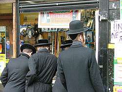
Stamford Hill is at the centre of an Ashkenazi ultra-Orthodox Jewish and predominantly Hasidic community estimated to be some 30,000 strong and growing at a rate of around 5% each year.[2][12] It is the largest Hasidic community in Europe, and referred to as a square mile of piety,[9] reflecting the many Jewish men seen walking in their distinctive clothes on their way to and from worship. The congregations often represent historical links with particular areas of Eastern Europe in their dress and their worship. Many also retain international links with other congregations around the world. The largest of these congregations is the Satmar, which has five directly associated synagogues; Belz is another large community with several synagogues. In the surrounding area there may be over 50 synagogues, and many observant Jews in the neighbouring areas of Stoke Newington, Upper Clapton and Tottenham identify with Stamford Hill.
A volunteer emergency response first-aid service called Hatzola (the Hebrew word for rescue) and a volunteer community watch group called Shomrim[13] (the Hebrew word for watchmen) are run by, and largely for, the Jewish community.[14] The need for dietary observance means that Stamford Hill has a large number of shops selling specifically Kosher food.
The strictly orthodox Jewish community relies mostly on private education for schooling, with almost all Jewish children attending private, single-sex Jewish schools.[15] In 2005, however, the Stamford Hill Yesodey Hatorah Senior Girls' School achieved voluntary-aided status.[16] The school has made headlines several times, most recently when some of its pupils refused to study Shakespeare due to his alleged anti-Semitic views, and the school's principal, Rabbi Abraham Pinter, saluted the girls for having pride in their beliefs.[17] In 2014, the Oxford, Cambridge and RSA (OCR) Exam board, having conducted an investigation into alleged exam malpractice, concluded that the school had redacted (deleted) questions involving the evolution of species on GCSE science exam questions.[18][19] Ofqual subsequently ruled that blocking out exam questions is malpractice, and, accordingly, not permissible.[20]
Haredi families on average have 5.9 children, almost 2.5 times the average for England and Wales, and many families live in overcrowded flats.[21] National planning regulations are applied by the local council, prohibiting "excess" development of family housing. This has led to conflict between the council and the Jewish population, represented by the Union of Orthodox Hebrew Congregations. Agudas Israel Housing Association is active in developing housing for the Jewish community in Stamford Hill.[15]
There is also a notable population of Yemenite Jews, especially Adeni Jews who originated in the port city of Aden in Yemen. They settled in Stamford Hill after fleeing the inter-community violence at the end of the Aden Protectorate. The Adeni Congregation synagogue, Nahalat Yosef, is named after the original Adeni synagogue in Yemen.[22] A new synagogue has been built, modelled on the original one. Adeni Jews tend to consider themselves a different ethnicity to other Yemeni Jews, due to differences in traditions, prayers (pronunciation) and customs that have evolved under British rule. In recent years, many have moved to Southgate and Hendon.
In 2014 the community met with controversy after a sign was spotted in the location reading, "Women should please walk along this side of the road only".[23] The sign was reportedly put up for a Torah Procession parade and were meant to provide directions for members who wished to avoid contact with the opposite sex [23] After complaints about the sign were raised a group of Shomrim who regularly police the area contacted the organisers to tell them that the posters "lacked explanation" the posters were removed and the organisers agreed to take the signs down more quickly the following year.[24]
Demographics
The data table shows ONS Census data[25] for the wards around Stamford Hill, where respondents indicated a religion:[26]
| Ward | All | Christian | Buddhist | Hindu | Jewish | Muslim | Sikh | other | No religion | not stated |
|---|---|---|---|---|---|---|---|---|---|---|
| Cazenove | 13,392 | 3,823 | 93 | 70 | 2,868 | 2,210 | 122 | 53 | 2,730 | 1,423 |
| Lordship | 12,280 | 3,251 | 80 | 49 | 3,179 | 977 | 98 | 56 | 3,119 | 1,471 |
| New River | 12,551 | 3,965 | 102 | 40 | 3,591 | 1,362 | 48 | 33 | 1,870 | 1,540 |
| Springfield | 12,378 | 3,799 | 57 | 39 | 3,604 | 1,745 | 111 | 46 | 1,436 | 1,541 |
| Seven Sisters | 15,968 | 6,219 | 165 | 165 | 2,883 | 2,338 | 75 | 73 | 2,639 | 1,411 |
| Total | 66,569 | 21,057 | 497 | 363 | 16,125 | 8,632 | 454 | 261 | 11,794 | 7,386 |
- The London Borough of Hackney has expressed its concern that Haredi-Jewish residents are seriously under-counted in the Census data, as the religion question is voluntary[27]
Education
The Jesuit order founded St Ignatius' College on 10 September 1894, in two houses called Morecombe Lodge and Burleigh House near Tottenham High Road. In 1907 the College was recognised by the Board of Education and began to receive public money. Notable former pupils of St Ignatius include Alfred Hitchcock and Cardinal Heenan. It remained at Stamford Hill as a grammar school until 1968, and then became a two-tier, seven-form entry comprehensive school, the Lower School being located at the old Cardinal Allen School in Enfield, and the Upper School in Stamford Hill. In 1987, the Upper School also moved away from Stamford Hill, when both parts of the school were united in Enfield in the course of a major building programme.
Today, Lubavitch Senior Girls' School, Our Lady's Convent RC High School, Skinners' Academy and Yesodey Hatorah Senior Girls' School are secondary schools located in the area.
There are also many independent or Haredi schools in the area.
Transport and locale
 |
Hornsey | South Tottenham | Walthamstow | |
| Manor House | |
Leyton | ||
| ||||
| | ||||
| Finsbury Park | Stoke Newington | Upper Clapton |
- Nearest stations
- Stamford Hill railway station
- South Tottenham railway station
- Manor House tube station
- Seven Sisters station
- Stoke Newington railway station
Notable residents
- Sadik Ahmed (born 1977), British film director and cinematographer
- Ronald Wilberforce Allen (1889-1936), English lawyer and Liberal politician
- Bernard Butler (born 1970), English musician and record producer
- Michael Duane (1915-1997), teacher
- Aba Dunner (1937-2011), social and religious activist
- Lennie Felix (1920-1980), British jazz pianist
- Margery Fish (1892-1969), English gardener and gardening writer
- Leo Genn (1905-1978), British stage and film actor and barrister
- William Brodie Gurney (1777–1855), English shorthand writer and philanthropist
- Nathan Moore (born 1965), English musician and manager
- Shloime Gertner, Hasidic Jewish singer
- Samuel Morley (1809-1886), English manufacturer, philanthropist, and statesman
- Shulem Moshkovitz (died 1958), Shotzer Rebbe
- Richard Negri (1927-1999), British theatre director and designer
- David Pearl, property developer
- Harry Roy, (1900-1971), British dance band leader and clarinetist
- Moishe Sternbuch, vice-president of the Jerusalem rabbinical court
- Leona Lewis, singer, songwriter, vocal producer and animal welfare campaigner.
- Herschel Gluck, Rabbi connected to ChaBaD London with relations to the central Europa,
See also
- Mavar, an organisation which supports those who wish to leave the Haredi lifestyle in the UK, many of whom come from Stamford Hill.
- Stamford Bridge, a completely different area on the other side of London
References
- ↑ http://data.london.gov.uk/visualisations/atlas/ward-profiles-html/atlas.html
- 1 2 http://www.destinationhackney.co.uk/neighbourhoods/stamfordhill.asp
- ↑ http://www.ons.gov.uk/ons/dcp171778_333877.pdf
- ↑ http://www.hackney.gov.uk/Assets/Documents/stamford-hill-area-Statement-of-Need.pdf
- ↑ Georgian Transport (Brickfields Spitalfields) accessed 18 May 2009
- ↑ The North Metropolitan Tramways Co. inaugurated 1872, and ran from Moorgate via Kingsland and Stoke Newington Roads to Stamford Hill
- ↑ The North Metropolitan from Bishopsgate ran through Mare Street, and thence to Clapton, opened in 1872, and was extended to Clapton Common in 1875, reaching Stamford Hill in 1902
- ↑ 'Hackney: Communications', A History of the County of Middlesex: Volume 10: Hackney (1995), pp. 4-10 Date accessed: 1 November 2006.
- 1 2 3 'Hackney: Judaism', A History of the County of Middlesex: Volume 10: Hackney (1995), pp. 145-48. Date accessed: 31 October 2006.
- ↑ ODNB entry by Catherine Horwood. Retrieved 2 November 2012. Pay-walled.
- ↑ Kosher in the country The Economist 1 June 2006 accessed 14 August 2007
- ↑ "Learning Trust" (PDF). Retrieved 25 March 2011.
- ↑ Stamford Hill Shomrim - About http://www.londonshomrim.com/about-us.html
- ↑ Jewish health service offers local care - BBC Health 19 January 2003 accessed on 11 December 2006
- 1 2 Mick Brown (25 February 2011). "Inside the private world of London's ultra-Orthodox Jews". London: The Telegraph. Retrieved 2 March 2011.
- ↑ Ofsted report accessed 19 June 2009
- ↑ School falls down league tables after pupils boycott 'anti-Semitic' Shakespeare Sarah Harris Daily Mail (29 February 2008) accessed 19 June 2009
- ↑ "Jewish faith school caught censoring questions on science exam papers". secularism.org.uk/. 2013-10-10. Retrieved 2013-10-10.
- ↑ "Jewish school redacts exam to remove evolution questions". bbc.co.uk/. 2014-03-04.
- ↑ "Evolution exam questions cannot be blocked, says Ofqual". 2014-03-31.
- ↑ Ynet London haredim considering move (Reuters/YNET 1 October 2006) accessed 19 June 2009
- ↑ The synagogues are named for the book Nahalat Yosef by Shemu'el Yosef Yeshuah. The book is named for his father, but contains a systematic exposition of rabbinical law and ethics. A second part details his travels in Palestine and the particular customs of Adeni Jews. In The Jews of the British Crown Colony of Aden Reuben Ahroni pp. 170–1 (Brill, 1994) ISBN 90-04-10110-1
- 1 2 Saul, Heather. "Stamford Hill council removes 'unacceptable' posters telling women which side of the road to walk down". The Independent. Retrieved 29 September 2014.
- ↑ Blundy, Rachel. "Hackney council removes 'unacceptable' posters telling women which side of the road they should walk on". The Evening Standard. Retrieved 29 September 2014.
- ↑ Office For National Statistics, 2011 Census, at Nomisweb accessed on 24 November 2014
- ↑ In the 2011 UK census, respondents were voluntarily asked to identify their religion.
- ↑ 'Torah, worship and acts of loving kindness' - Christine Holman and Naomi Holman, De Montfort University, November 2002.
External links
- memories of Montefiore House School 1944-1950
- 2001 Census profile: The Jewish population of London - GLA Data Management Group (September 2006) accessed 13 December 2006
- The Reservoirs Nature Society (TeRNS)
| Districts |  | |
|---|---|---|
| Attractions | ||
| Parks and open spaces | ||
| Street markets | ||
| Constituencies | ||
| Tube and rail stations | ||
| Other topics | ||