Stape
Coordinates: 54°19′42″N 0°46′55″W / 54.328400°N 0.781900°W
Stape is a hamlet and civil parish in the Ryedale district of North Yorkshire, England. At the 2011 Census the population was less than 100. Details are included in the civil parish of Cropton. It is in the North York Moors National Park, 7 – 8 miles north of Pickering. There is an activity centre, known as the Ken Ather Outdoor Centre, built for use by pupils of Joseph Rowntree school.
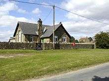
The Ken Ather Outdoor Centre, Stape, formerly a school
| Wikimedia Commons has media related to Stape. |
This article is issued from Wikipedia - version of the 2/15/2016. The text is available under the Creative Commons Attribution/Share Alike but additional terms may apply for the media files.