Steling
| Steling | |
|---|---|
|
Steling | |
| Highest point | |
| Elevation | 658.3 m (2,160 ft) |
| Coordinates | 50°34′40″N 6°12′44″E / 50.57778°N 6.21222°ECoordinates: 50°34′40″N 6°12′44″E / 50.57778°N 6.21222°E |
| Geography | |
 Steling Border of North Rhine-Westphalia, Germany / Province of Liege, Belgium | |
| State/Province | DE-NW/BE-WLG |
| Parent range | Eifel |
The Steling is a mountain, 658.3 m above sea level (NN),[1] and thus the highest point in the municipal region of Aachen. The German-Belgian border runs over the mountaintop.
Location
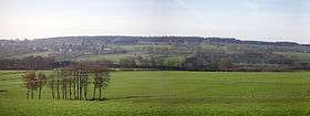
The Steling is located on the western edge of the High Fens-Eifel Nature Park. At its southern foot lies Mützenich, a quarter of Monschau. On its northern slopes is the source region of the River Weser, which flows through the Weser Dam near Eupen to Liege and into the Ourthe.
Climate
The High Fens to the south and west benefit from the Steling, because the summit causes moist Atlantic winds to release their rainfall on the mountain.
Tourism and information
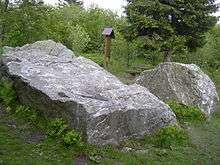
About 700 metres southwest of the highest point on the mountain is a tourist attraction: the striking quartzite rocks known as Emperor Charles' Bed (Kaiser Karls Bettstatt).
On the mountain and its surrounding pastures may be seen field hedges of beech, typical of the Monschau Hedge Land, which are used to enclose the grazing pastures and hay meadows.
From the top of the Steling there is an extensive overview of the North Eifel and, in good visibility, visitors can see as far as the Siebengebirge near Bonn and Cologne Cathedral.
On the Steling there is a private weather station for the Rureifel and Monschau region, whose services are used by the surrounding villages.
References
- ↑ Map service of the BfN
External links
| Wikimedia Commons has media related to Steling. |