Stepenitz (Trave)
.jpg) | |
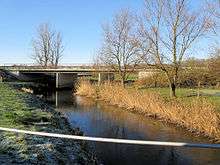
| The Stepenitz between Mühlen Eichsen and Rüting | |
| Location | Mecklenburg-Western Pomerania, Germany |
|---|---|
| Reference no. | DE: 9628 |
| Length | 52 km |
| Source | Northwest of Schwerin and the Neumühler See 53°39′55″N 11°16′49″E / 53.66539°N 11.28037°ECoordinates: 53°39′55″N 11°16′49″E / 53.66539°N 11.28037°E |
| Source height | ca. 49 m above sea level (NHN) |
| Mouth | Into the Pötenitzer Wiek 53°54′25″N 10°58′00″E / 53.90694°N 10.96667°E |
| Basin | Trave |
| Progression | Trave → Baltic Sea |
| Catchment | 701 km² [1] |
| Right tributaries | Poischower Mühlenbach |
| Left tributaries | Radegast, Maurine |
| Lakes passed | Rehmsee, Cramoner See, Dalbergkuhle, Wendelstorfer See, Groß Eichsener See, Dassower See |
| Reservoirs passed | Speicher Faulmühle |
| Cities | Lübeck |
| Small towns | Dassow |
| Villages | Brüsewitz, Cramonshagen, Dalberg-Wendelstorf, Mühlen Eichsen, Rüting, Stepenitztal |
The Stepenitz is a right-hand tributary of the River Trave in the northwest of the German state of Mecklenburg-Western Pomerania and within the borough of Lübeck in the state of Schleswig-Holstein.
Course
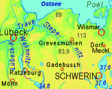
Th river rises northwest of city of Schwerin and the lake of Neumühler See near the Brüsewitz settlement of Eulenkrug and north of a hill ridge[2] at a height of about 49 m above sea level (NHN). From there it first flows through the Rehmsee and then a succession of other lakes, including the Speicher Faulmühle, the Cramoner See, the Wendelstorfer See and the Groß Eichsener See. Continuing to head northwest, it collects the River Radegast in Börzow and the Maurine four kilometres before Dassow. The river section from Rüting to Dassow has numerous meanders.
Just behind the Dassow Bridge in Lübeck the Stepenitz empties into the Dassower See. Through this lake its waters reach the Pötenitzer Wiek, a bay of the Trave river, the Priwall Peninsula and Mecklenburg, where the Stepenitz discharges into the Trave at sea level. A few hundred metres further north, by Travemünde, the Trave reaches the Baltic. The length of the river from source to its mouth on the Dassower See is 52 kilometres. Its catchment covers an area of 701 km².[1]
Watersheds
The source region of the Stepenitz lies on the North Sea-Baltic Sea Watershed. While the Stepenitz flows in a northwesterly direction via the Trave to the Baltic, the waters of the Sude, which rises just a few kilometres further southwest and heads in a southwesterly direction, run via the River Elbe to the North Sea.
Gallery
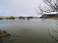 High water at the confluence of the Stepenitz and Radegast in March 2010
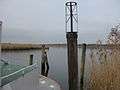 Mouth of the Stepenitz on the Dassower See
See also
References
- 1 2 Minister für Bau, Landesentwicklung und Umwelt (publ.): Gewässergütebericht 1994, Schwerin, 1996, p. 16
- ↑ Local maps and Ursprung der Stepenitz, Freimüthiges Abendblatt, Schwerin, Vol. 17/1835 (digitalised; pdf; 112 kB) and Ministry of the Environment, Mecklenburg-Vorpommern: Gewässergütebericht 1993, Schwerin, 1994, p. 58
External links
| Wikimedia Commons has media related to Stepenitz (Trave). |