Sterling Center Historic District
|
Sterling Center Historic District | |
|
Sterling Center | |
  | |
| Location | Sterling, Massachusetts |
|---|---|
| Coordinates | 42°26′10″N 71°45′41″W / 42.43611°N 71.76139°WCoordinates: 42°26′10″N 71°45′41″W / 42.43611°N 71.76139°W |
| Architect | Unknown |
| Architectural style | Greek Revival, Late Victorian, Federal |
| NRHP Reference # | [1] |
| Added to NRHP | April 14, 1988 |
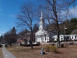
The Sterling Center Historic District is a historic district encompassing the central village of Sterling, Massachusetts. The district is roughly bounded by Meetinghouse Hill and Main, Maple and Kendall Hill, Boulding, Worcester and Princeton Street. The town common, which is the focal point of the district, was laid out in 1724, when the area was still part of Lancaster. The area includes 18th- and 19th-century houses, as well as several church buildings, and the 1835 town hall.[2]
The district was added to the National Register of Historic Places in 1988.[1]
See also
References
- 1 2 National Park Service (2008-04-15). "National Register Information System". National Register of Historic Places. National Park Service.
- ↑ "MACRIS inventory record for Sterling Center Historic District". Commonwealth of Massachusetts. Retrieved 2014-03-15.
| Topics |  | ||||||||||||||||||||||||||||||
|---|---|---|---|---|---|---|---|---|---|---|---|---|---|---|---|---|---|---|---|---|---|---|---|---|---|---|---|---|---|---|---|
| Lists by county | |||||||||||||||||||||||||||||||
| Lists by city |
| ||||||||||||||||||||||||||||||
| Other lists | |||||||||||||||||||||||||||||||
| |||||||||||||||||||||||||||||||
This article is issued from Wikipedia - version of the 11/27/2016. The text is available under the Creative Commons Attribution/Share Alike but additional terms may apply for the media files.