Strait of Otranto
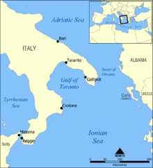
The Strait of Otranto (Albanian: Kanali i Otrantos; Italian: Canale d'Otranto) connects the Adriatic Sea with the Ionian Sea and separates Italy from Albania. Its width at Punta Palascìa, east of Salento is less than 72 kilometres (45 mi).[1] The strait is named after the Italian city of Otranto.
History
Since ancient times the Strait of Otranto was of vital strategic importance. The Romans used it to transport their troops eastwards. The legions marched up to Brundisium (now Brindisi), had only a one-day voyage to modern Albania territory and then could move eastwards following Via Egnatia.
During World War I, the strait was of strategic significance. The Allied navies of Italy, France, and Great Britain, by blockading the strait, mostly with light naval forces and lightly armed fishermen, hindered the cautious Austro-Hungarian Navy from freely entering the Mediterranean Sea, and effectively kept them out of the naval theatre of war.
However, the barrage was notoriously ineffective against the German U-boats operating out of the Adriatic, which were to plague the Allied powers for most of the war throughout the Mediterranean.[2]
In 1992, Albania and Italy signed a treaty that delimited the continental shelf boundary between the two countries in the strait.
In 1997 and 2004, nearly 100 people lost their lives trying to illegally cross the strait following the 1997 unrest in Albania and poor economic conditions in the Tragedy of Otranto and the Karaburun tragedy.
In 2006, the Albanian government imposed a moratorium on motor-powered sailing boats on all lakes, rivers, and seas of Albania to curb organized crime.[3] The only exemption to the rule are government owned boats, foreign owned boats, fishing boats, and jet boats. In 2010, the moratorium was extended for 3 more years, until 2013.
See also
References
- ↑ Frank K. McKinney (2007). The Northern Adriatic Ecosystem: Deep Time in a Shallow Sea. Columbia University Press. p. 29. ISBN 978-0-231-13242-8. Retrieved 6 March 2013.
- ↑ First World War - Willmott, H.P., Dorling Kindersley, 2003, Page 186
- ↑ http://www.keshilliministrave.al/?fq=brenda&m=news&lid=1850 Council of Ministers of the Republic of Albania, www.keshilliministrave.al, 10 August 2006.
Coordinates: 40°13′10″N 18°55′32″E / 40.21944°N 18.92556°E