Stranda, Møre og Romsdal
This article is about the village in Stranda, Møre og Romsdal county, Norway. For the municipality, see Stranda Municipality.
| Stranda | |
|---|---|
| Village | |
|
View of the village | |
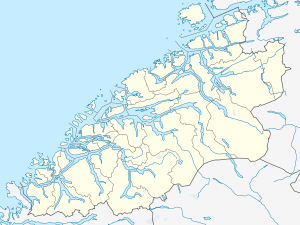 Stranda  Stranda Location in Møre og Romsdal | |
| Coordinates: 62°18′31″N 06°56′13″E / 62.30861°N 6.93694°ECoordinates: 62°18′31″N 06°56′13″E / 62.30861°N 6.93694°E | |
| Country | Norway |
| Region | Western Norway |
| County | Møre og Romsdal |
| District | Sunnmøre |
| Municipality | Stranda Municipality |
| Area[1] | |
| • Total | 2.38 km2 (0.92 sq mi) |
| Elevation[2] | 30 m (100 ft) |
| Population (2013)[1] | |
| • Total | 2,907 |
| • Density | 1,221/km2 (3,160/sq mi) |
| Time zone | CET (UTC+01:00) |
| • Summer (DST) | CEST (UTC+02:00) |
| Post Code | 6200 Stranda |
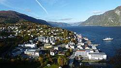
Stranda is the administrative centre of Stranda Municipality in Møre og Romsdal county, Norway. The village is located on the western shore of the Storfjorden.[3] The 2.38-square-kilometre (590-acre) village has a population (2013) of 2,907; giving the village a population density of 1,221 inhabitants per square kilometre (3,160/sq mi), and making it the largest settlement in the municipality.[1]
The village is the shopping and industry center of the municipality. It lies along Norwegian County Road 60, and there is a ferry connection to the village of Liabygda, across the fjord. The village of Helsem lies about 2 kilometres (1.2 mi) south of Stranda. Stranda Church is located in Stranda.
References
- 1 2 3 Statistisk sentralbyrå (1 January 2013). "Urban settlements. Population and area, by municipality.".
- ↑ "Stranda" (in Norwegian). yr.no. Retrieved 2013-06-29.
- ↑ Store norske leksikon. "Stranda – tettstedet" (in Norwegian). Retrieved 2013-06-29.
This article is issued from Wikipedia - version of the 8/1/2016. The text is available under the Creative Commons Attribution/Share Alike but additional terms may apply for the media files.