Strefford
| Strefford | |
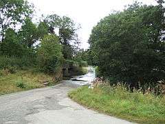 The ford at Strefford, as seen in the summer; there is a footbridge to the side |
|
 Strefford |
|
| OS grid reference | SO443855 |
|---|---|
| Civil parish | Wistanstow |
| Unitary authority | Shropshire |
| Ceremonial county | Shropshire |
| Region | West Midlands |
| Country | England |
| Sovereign state | United Kingdom |
| Post town | CRAVEN ARMS |
| Postcode district | SY7 |
| Dialling code | 01588 |
| Police | West Mercia |
| Fire | Shropshire |
| Ambulance | West Midlands |
| EU Parliament | West Midlands |
| UK Parliament | Ludlow |
|
|
Coordinates: 52°27′54″N 2°49′08″W / 52.465°N 2.819°W
Strefford is a historic hamlet in Shropshire, England.
It lies in the civil parish of Wistanstow and is situated just off the A49 road 2 miles (3.2 km) north of the small town of Craven Arms. The nearest settlement is Upper Affcot, to the north on the A49, a hamlet which has a public house. Strefford is at an elevation of between 130 metres (430 ft) and 135m, and just to the east is Strefford Wood which is at the southern end of Wenlock Edge; the bridleway that runs along the Edge ends just outside the hamlet.[1]
Strefford was recorded in the Domesday Book as 'Straford' and in 1255 as 'Streford'.[2] The name derives from its situation between the Roman road (a "Street") at Wistanstow (to the west) and the ford immediately to the east of the hamlet,[2] which crosses the Byne or Quinny Brook. The Byne and Quinny Brooks meet just prior to the ford and only a mile after flow into the River Onny.[1]
There is a farm shop[3] and bed and breakfast[4] at Strefford Hall.
Strefford Conservation Area covers all the settlement, including the ford.[5] There are five Listed buildings in the hamlet: Ford Cottage, Malt Cottage, The Cottage, the (disused) parish pumphouse, and Strefford Cottages; in addition there is a Listed milestone on the A49 road at Strefford.[6] The village lies within the Shropshire Hills Area of Outstanding Natural Beauty designation.
References
| Wikimedia Commons has media related to Strefford. |
- 1 2 Ordnance Survey mapping
- 1 2 Poulton-Smith (2009) Shropshire Place Names p 136
- ↑ Stefford Hall Farm Shop
- ↑ Strefford Hall B & B
- ↑ Strefford Conservation Area (Shropshire Council) PDF
- ↑ British Listed Buildings Wistanstow map