Sula River (Mezen)
Coordinates: 64°41′29″N 47°47′23″E / 64.69139°N 47.78972°E
| Sula Russian: Сула | |
|---|---|
| Country | Russia |
| Basin | |
| River mouth | Mezen |
| Basin size | 2,210 km2 (850 sq mi)[1] |
| Physical characteristics | |
| Length | 221 km (137 mi)[1] |
| Discharge |
|
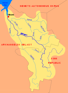
The Sula (Russian: Сула) is a river in Leshukonsky District of Arkhangelsk Oblast in Russia. It is a right tributary of the Mezen River. It is 221 kilometres (137 mi) long, and the area of its basin 2,210 square kilometres (850 sq mi). The major tributaries of the Mezenskaya Pizhma are the Pyshega River and the Omza River (both left).
The Sula starts on the Kozminsky Kamen Plateau, part of the Timan Ridge. It generally flows in the south-western direction.
The valley of the Sula is one of the most remote areas of Arkhangelsk Oblast. There are no settlements on the river, except for the village of Zasulye in the mouth of the Sula. There are several wooden houses, located all over the river course and used by seasonal hunters. In the middle course of the Sula, a road runs parallel to the river. This road connects the Mezen valley (the village of Ust-Kyma) with the Pechora valley (the village of Ust-Tsilma) and is not passable for ordinary cars.
References
- 1 2 3 Сула (река, приток р. Мезень). Great Soviet Encyclopedia.
External links
- Река Сула (in Russian). State Water Register of Russia. Retrieved 10 August 2011.